

Mt. San Antonio, more commonly known as Mt. Baldy, is a 10,064ft mountain peak located in the San Gabriel range of Southern California. There are numerous routes to the summit, with the most popular being Devil’s Backbone and Skit Hut Trail. For winter adventurer’s looking for an introduction to mountaineering, Mt. Baldy offers the steep and challenging Baldy Bowl route. I cannot stress enough the importance of safety on this route. Do not attempt this hike without the proper gear and training. You should at the very least have an ice axe and crampons. You may also want to consider a helmet. Make sure to have training for self arrest should you need it. REI holds self arrest seminars on this very route. It is also possible to hike Baldy Bowl in the snow free months, but with such loose terrain on a steep mountain, I do not recommend it.


Directions:
- The trailhead to hike Baldy Bowl Trail is located at Manker Flat, the same trailhead that is used for Devil’s Backbone and Ski Hut Trail for ascents of Mt. Baldy. Click here for directions
- From the 210 freeway, exit Baseline (eastbound) or Mountain (westbound) and head north towards Mt. Baldy Road and Mt. Baldy Village. Continue past Mt. Baldy Village and take a left towards the Mt. Baldy Ski Resort when you see the parking lot for Icehouse Canyon. The trailhead is just after the Manker Flat camping area and just before the ski lift parking lot.
- Download GPX
- See my track on Strava
Key Points:
- Distance: 8 miles
- Elevation Gain: 3980 ft
- Minimum Elevation: 6156 ft
- Maximum Elevation: 10064 ft
- Time: 5-7 hours
- Difficulty: Advanced
- Dog Friendly: Yes, but not advisable
- Permit Required: No, Adventure Pass Required To Park
- Season: Year Round, But Best In Winter With Snow
- Trail Condition: Well On Ski Hut, Use Trail Up Baldy Bowl
Make sure to hike with the right gear. See my current hiking gear list.
Hike Map And Elevation Profile:
As you can see in the Google Earth image below, the actual Baldy Bowl route on this climb is fairly short, but very steep. The vast majority of this hike takes place on the Ski Hut Trail, also known as the Baldy Bowl Trail.


Climbing up the Baldy Bowl route takes hikers up 1800ft of elevation in a little over a mile. Make sure you’re in shape for this one, as you do not want to run out of gas half way up the mountain.


Hike Description:
As I mentioned above, much of this hike takes place on the Skit Hut Trail. I’m going to assume that you have hiked to the summit of Mt. Baldy via Ski Hut Trail (and/or Devil’s Backbone, Bear Canyon, Register Ridge) before taking on this Winter ascent. For that reason, I’m going to be brief in my description of the first two miles, as you’re probably already familiar with this section of the trail.
From Manker Flat parking area, walk past the port-o-potties and yellow gate up the paved Mt. Baldy Rd. towards San Antonio Falls. Once you pass San Antonio Falls, you’ll begin hiking on a fire road. Keep an eye out to your left for the start of the Ski Hut Trail, marked by a broken trail sign reading “Baldy Bowl Trail”.

Continue on Ski Hut Trail for 2.5 miles until you reach the green San Antonio Ski Hut. The San Antonio Ski Hut sits at 8300ft and belongs to the Sierra Club. Offering a fully equipped kitchen with dishes, water, and lighting, the Skit Hut is a pretty nice place to house up to 16 people. The rate is $20 for non Sierra Club members, and $16 for members. You can contact a hut host for more information.


After leaving the Ski Hut behind, the Ski Hut Trail cuts through the base of the Baldy Bowl and climbs up a ridge to the west. Instead of heading towards this ridge, you’ll want to look to your right (north), and begin climbing straight up the Baldy Bowl. There are a number of different routes you can take, and you’ll notice more than a few use trails in the snow if it’s been more than a few days after a storm.


Baldy Bowl is a steep and unrelenting route. There are few places to take a break or adjust your gear once you get moving, so make sure you have everything dialed in before you head up.


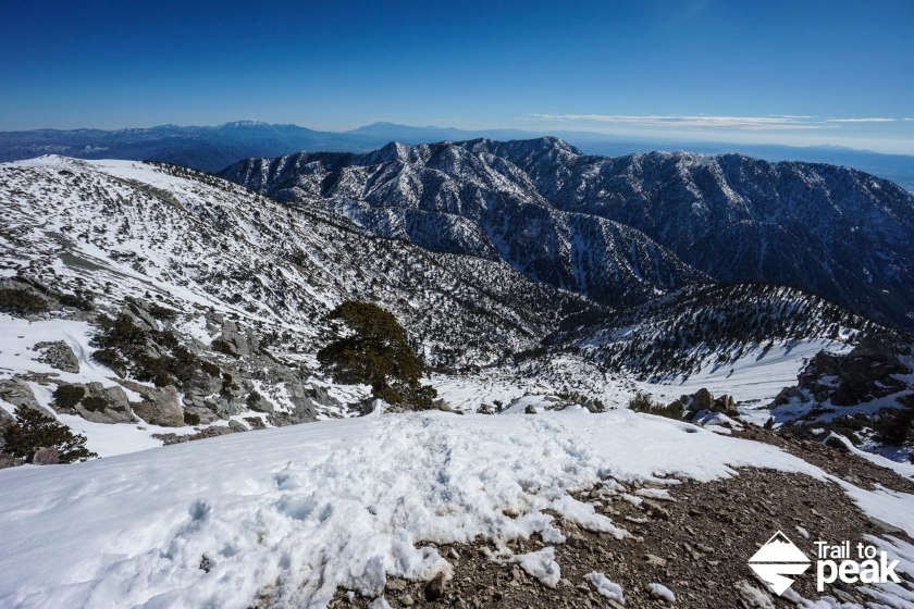
If you’re afraid of heights and/or get vertigo, this is not the hike for you. If you like the feeling of being on top of the world, you’re going to love it! Don’t forget to turn around and enjoy the views every now and again. Once you’re half way up, the skies really start to open before you. The northern side of the front range is in full view, with fan favorites like Cucamonga and Ontario Peak.


With about 800ft to the summit, the Baldy Bowl trail starts to stiffen up for the steepest climbing of the day. Many choose to cut uphill in a narrow switchback pattern to ensure their footing. Other more daring climbers venture off towards the steeper chutes.


With 300ft of elevation and .2 miles to the summit of Mt. Baldy, you’ll climb up and out of Baldy Bowl. This section will feel easy after what you’ve just climbed.

After hiking nearly 4,000ft in 3.4 miles, you’ll be standing on the 10,064ft summit of Mt. Baldy. The views from the summit can be pretty spectacular on a clear day. It’s not unusual to see Catalina Island, San Gorgonio, San Jacinto, Baden Powell, Iron Mountain, and many more SoCal favorites. On the day I catalogued this hike, I observed an event I’m not likely to see anytime soon. A helicopter crashed on the saddle between West Baldy and Mt. Baldy.


Your return route will largely depend on the trail conditions and snow depth. Some hikers will glissade down Baldy Bowl if there is enough snow. Be very careful though if you choose this option, as there are some very large and sharp rocks. I chose to hike down Ski Hut Trail, for a casual and relaxed 4 mile descent. The choice is yours.

I hope you’ve enjoyed this hike write up. Feel free to leave me any questions or comments in the field provided below.