
This is hike number 7/52 for the 52 Hike Challenge in 2015, and 76 out of my goal of 1000 miles this year. My standard hikes usually consist of a steady climb to a peak, and then a descent back to the trailhead. In order to train for John Muir Trail this summer, I’m going to start incorporating multiple peaks for certain hikes with varied climbs to simulate the changing elevation on the JMT. Yesterday, I started at the Icehouse Canyon trailhead and made my way to the Icehouse Saddle. From the saddle, I first reached the summit of Ontario Peak (8,694 ft), then I walked along the ridge to Bighorn Peak (8,441 ft) before descending and climbing to Cucamonga Peak (8,858 ft). The round trip total for this hike was 16 miles.
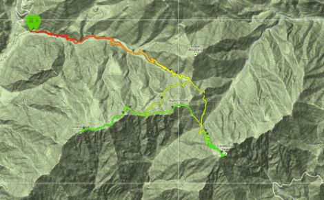
Upon waking up on Sunday, I almost decided not to go on this hike. The Santa Ana winds had been blowing with venom all weekend, and I could still hear them roaring outside at 6 AM. With a consistent flow of 35 MPH winds and gusts up to 50 MPH in the valley, I knew things would be even more powerful in the mountains. In the end I decided to take a chance to see how things played out. Unsurprisingly, the Icehouse Canyon trail was fairly empty for my later than usual start time of 8:30 AM. I made it up to the saddle in about 1:15 and proceeded towards Kelly Camp and Ontario Peak.

The wind had been somewhat tame and muted by the canyon walls. This all changed as I reached the ridge junction that splits the trail for Bighorn Peak and Ontario Peak. The wind was coming in strong bursts which made it a bit difficult to move smoothly on the crusty ice laden trail. Looking down into the Inland Empire, I could see a fire burning in the Chino area. It was interesting to see the flow of air and smoke dispersion throughout the valley.


I made it to Ontario Peak in one piece, and just as I scrambled up the rocks to take a picture, the wind really started to fire away. It made it very difficult to keep my balance and I was losing warmth quicker than I had planned on. Without taking much of a break or spending time at my first peak, I put my camera away and headed back towards Bighorn Peak.


The distance between Ontario Peak and Bighorn Peak is not very far, but the wind made the ridge hike tougher than usual. In a nice turn of events, the wind began to die down as I began my climb to the summit of Bighorn Peak which allowed me to take a short break and get some blood flowing in my face again.

There isn’t an official trail from the summit of Bighorn Peak to the saddle where you can pick up the Cucamonga Peak trail. If you just drop down towards Cucamonga Peak and follow the ridge, you’ll run right into it. Taking this route in winter is much nicer than the summer time, as there is far less dust kicked up with each step and the footing is a bit more steady.
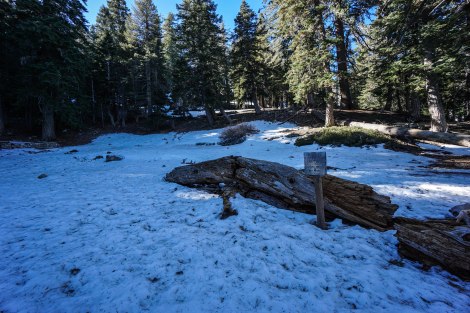
I haven’t hiked Cucamonga Peak after 11:00 AM for quite some time, so it was interesting to see the mountain in a different light with all of the snow. Given different lighting conditions, a trail can feel like a completely different place. After hiking to the summit of Ontario Peak and Bighorn Peak without seeing anyone, it was nice to finally see a group making their way up Cucamonga Peak. The footing to the summit was pretty good, and after hiking for more than 4 1/2 hours, I reached peak #3.


The hike back down was relatively uneventful, but I was really enjoying the fact that the wind had all but stopped. I could feel the windburn on my face, but the clouds were blocking all of the sunlight at this point, so the exposure wasn’t too bad. It was a great day for training and hiking, and my legs felt really good throughout. I’m going to continue on with this style of hiking for John Muir Trail and I should be good to go by July.
Beautiful photos! I envy those mountain trails for training…
Thanks! It’s really nice to have these trails within a 30 minute drive.
Great photos!
Thanks!
Great photos and it sounds like an awesome hike! I’m looking forward to reading about your next trip!
Hey, thanks!
Nice snaps
Thanks!
Man those winds sure can put a damper on a hike! Great job training, you’re definitely on your way to being in great shape for the JMT miles.
They can for sure!
Beautiful photos!
Thanks!
Hey Drew – are these taken with that Sony you had posted about earlier? Have you always used Sony cameras?
Hello Erik! Yes, these were taken with my Sony a6000 and Sony 10-18mm lens. This is actually my first Sony. When I first starting shooting, about 10 years ago, I bought an entry level Nikon. After that, I shot with Canon up until last year.
I was potentially looking at the canon M series to size down but be able to utilize my lenses. Did you look into that one at all?
Hey Erik, I looked at the Canon EOS M, but the reviews were so bad that my research didn’t get very far. I know that Canon has invested some more time and money into mirrorless and will have some new offerings that will improve upon this.
Looks amazing! I like the hiking challenge…I should do it myself.
It definitely keeps me motivated and eager to find new trails!
Every day I find a new trail I want to do…
Great shots! Did you use your new camera?
Hello Dale, this was with my Sony a6000.
Oops. Somehow, I missed the earlier camera comment. I typically use my trusty lightweight Nikon D40. However, I have been considering moving to the Sony you are using. Enjoyed your write up and your hiking challenge. Much more ambitious than mine!
Dale, the Nikon D40 was my very first camera. It was a great lightweight DSLR for backpacking in South America. Thanks for checking out my blog!
Great report, do you have a gpx of this hike?
I think I do. Email me and I can send it to you.