
Buzzard Peak is the highest point in the San Jose Hills, a small range that parallels the 10 freeway and separates the cities of Covina, Walnut, and Diamond Bar. At 1345 ft, Buzzard Peak provides commanding 360° views of Los Angeles, the Inland Empire, and the San Gabriel Mountains. There are a few approaches to Buzzard Peak, but the most popular route starts on Grand Ave in West Covina via Magnolia Trail. This short 3-mile urban hike gains a modest 820 ft of elevation, and offers some really nice views on a clear day.

Getting There: Directions And GPS Track
- Magnolia Trail can be accessed via the 10 freeway Grand Ave exit or the 57 freeway Temple Ave exit. The trailhead is just around the corner from Mt. San Antonio Community College: 2242-2248 S Grand Ave, Covina, CA 91724
- The is no parking available at the trailhead. The Magnolia trail starts at the junction of Hillside and Grand, but residents of that area have erected “No Parking” signs all along Hillside. Your best bet is to park north at Cameron and Grand or south near Mt. SAC and walk along Grand Ave to the trailhead.
- Download GPX
- See track on Strava


Hike Profile
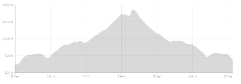
- Distance: 3.06 miles
- Elevation Gain: 802 ft
- Minimum Elevation: 692 ft
- Maximum Elevation: 1345 ft
- Time: 1-3 hours
- Difficulty: (2/5)
- Dog Friendly: Yes
- Permit Required: No
- Parking: No parking near trailhead. Must find parking along Grand Ave, and walk to Magnolia Trail.
- Weather: This hike can be very warm in the summer, but tends to be pleasant most of the year.
- Trail Condition: This trail combines a wide and well graded fire road with a little bit of buffed out single track.
- Cell Phone Reception: Very good
Do you have the appropriate gear for this hike? Don’t hike unprepared!
See my current hiking gear list.
Hike Map And Elevation Profile

Hike Description:
0.0 Miles (692 ft)- Starting on the east side of Grand Ave, you’ll see a trailhead marker that signifies the beginning of Magnolia Trail. The trail starts out heading uphill to the south and then zigzags on a few switchbacks.


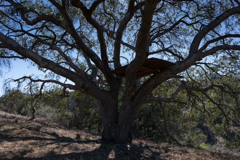
0.40 Miles (807 ft)- As you reach the top of the switchbacks, you’ll enter a shaded grove which is a nice respite from this mostly exposed trail. I’m not sure of the story behind it, but there is a teepee just off of the trail here.


After dipping out of the grove and passing the teepee, you’ll continue hiking on a few more exposed switchbacks.


0.70 Miles (932 ft) – Continuing up the switchbacks, you’ll walk past a ranch style house with a grazing area for horses. The horse might be out grazing depending on the weather.

After leaving the ranch house behind, you’ll start getting your first clear views of Buzzard Peak. As you continue hiking towards Buzzard Peak, you’ll pass through one more shaded grove, where a strangely placed palm tree marks the way.


1.10 Miles (1007 ft)- After passing the palm tree, you’ll walk behind a block of residential houses for the last stretch of hiking on Magnolia Trail. This part starts out fairly level, but begins to gain elevation with a quickness.


1.20 Miles (1106 ft)- At the 1.2 mile mark, you’ll see a lookout that signifies the end of the Magnolia Trail and the beginning of Buzzard Peak Road. This lookout sits just above Mt. SAC and also provides nice views out to LA (on a clear day).


Once you’ve enjoyed enough of the views on the lookout, hike uphill on Buzzard Peak Road for a short walk to the summit.

1.40 Miles (1214 ft)- As you approach Buzzard Peak, you’ll see that the fire road wraps around the summit block and a use trail leads directly to the top. The use trail is pretty steep, so make sure you have the shoes and skill if you choose that option. If you don’t want to take the use trail, continue on the fire road that wraps clockwise around Buzzard Peak.
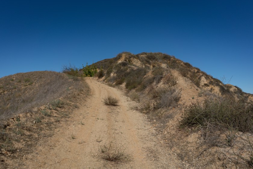

1.50 Miles (1266 ft)- Keep your eyes open for a use trail that starts from a hairpin turn on Buzzard Peak Road. It’s pretty obvious and hard to miss if you’re paying attention. This is the last stretch of trail on the way to the summit.

1.60 Miles (1345 ft)- When you reach the summit of Buzzard Peak, you’ll see views north to the San Gabriels, views west towards Los Angeles, views south towards Orange County, and views east towards the Inland Empire.
From this point, you can return on the same trail back to the Magnolia Trail starting point along Grand Ave.


Share This Post!

Our landscape and climate is similar to yours there in California. Your photos have a familiar look about them even though you are over on the other side of the world.
Very cool!
Now I can’t get Crazy Ex-Girlfriend out of my head (it takes place in West Covina). I wonder if they’ve done that hike haha 😀
Haha!!
Thanks for putting this together Drew! I really like the way you’ve laid out your post – the subheadings make it really easy to quickly find the info I want. Does this trail ever get green, like after winter rains?
Thanks for reading, Emily! It is actually very green in the rain.
6-23-2019 Your photos are nice. A clear day for a hike. Mine today was a hazy day & about 80F at 11 am. The trail today was nothing like your photo. The first 1/4 mi needed to be bushwhacked using my hiking pole. those dried grasses (mustard) were 4 to 7 ft high and also prickly plants (thistles) there too. Poison oaks just beyond those 2 palms on the right side of the trail up. The flag was gone, just the flag pole laying on the ground. Those white chairs (4) were still up there. Not a good sight . It took me 59 min to go up and 45 min to hike down to trailhead. As for parking your car, you cannot park on Grand Ave! Nearest parking place is on E. Cameron Ave , 1 block below the trailhead and ~ 1/4 mi on E. Cameron to Heritage Park.
Thanks for the update on the trail conditions, Tokuo. After the amount of rain we had over the winter, a lot of trails are in this ‘bushwacking’ condition. It has me worried for fire season once things dry out.