

Fossil Falls is a basaltic lava flow located just off of Highway 395 at the southern end of the Sierra Nevada Mountains. Many travelers pass by Fossil Falls on their way to Mt. Whitney, Lone Pine, Bishop, and Mammoth without realizing that a unique geologic feature sits just off of the highway. In this guide, I’ll provide all of the information you need to find Fossil Falls, hike out to the dry fall area, and find a place to camp if you’re looking to make this an overnighter.


During the last ice age that ended around 12,000 years ago, large glaciers formed in the Sierra Nevada mountains. Meltwater from these glaciers created large lakes and rivers. The Owens Lake and Owens River formed in the Indian Wells Valley and cut a path through the Coso Volcanic Field to create what we now call Fossil Falls. The flows from this glacier runoff polished the vesicular basalt into the smooth and twisting sculpture on display today.
Getting There: Directions And GPS Track
- From highway 395, you’ll take the eastbound Cinder Rd exit. This exit road can be very easy to miss, so keep an eye out for a large red cinder cone (a big volcanic hill) to know when to turn. The exit is located inbetween Lone Pine and Ridgecrest.
- Cinder Road starts out paved. You’ll soon take a right hand turn onto Fossil Falls Access Road.
- The trailhead for Fossil Falls starts at the Fossil Falls Scenic Area parking lot.
- Fossil Falls Scenic Area address: US highway 395, Olancha, CA 93549
- Download GPX
- See track on Strava


Hike Profile
- Distance: <1 miles
- Elevation Gain: 166 ft
- Minimum Elevation: 3250 ft
- Maximum Elevation: 3327 ft
- Time: <1 hours
- Difficulty: (1/5)
- Dog Friendly: Yes
- Permit Required: No
- Parking: Free parking located at the Fossil Falls Scenic Area trailhead
- Weather: This area can be hot in the summer, and cold and windy in the winter. Make sure to com prepared.
- Trail Condition: Level and flat trail with a lot of lava rock
- Cell Phone Reception: Pretty good
Do you have the appropriate gear for this hike? Don’t hike unprepared!
See my current hiking gear list.
Hike Map And Elevation Profile


Hike Description:
After you’ve exited highway 395 for Cinder Rd and made a right hand turn onto Fossil Falls Access Road, stay right at the upcoming junction. You’ll see a large Fossil Falls sign to your right, and a narrow Fossil Falls stake just off of the road. Continue on until you see the parking lot.


From the parking lot, you’ll see a large interpretive sign with information on Fossil Falls and information on some of the original inhabitants of the area. For those stopping by this area after a long car ride, there are public pit toilets available.


0.0 Miles- Starting from the interpretive sign in the parking lot, you’ll see a small trail junction marker with distance signage for Fossil Falls and the campground. Stay right at the junction and continue on towards the trail register.


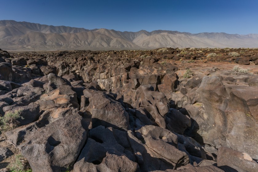
Once you pass the trail register the views really start to open up. There is black volcanic rock in every direction. It’s easy to see why so many people pass up Fossil Falls while driving on highway 395, the flat and barren landscape obscures the nearby falls quite well. Don’t forget to look back and enjoy the views of the Sierra Nevada range as well.


0.2 Miles- You’ll reach a fork junction early in the hike and just before you reach the falls. Stay on the left side of the fork to arrive at the top of Fossil Falls, with access points to hike down. If you take the right side of the junction you’ll have views from high above the gorge, but not many options to hike down further. There is a nice use trail connecting the points, so feel free to enjoy either one.
If you take the left side of the fork, keep your eye out for a large volcanic rock that looks like a shark fin, this will take you to the best spot to view the beautiful insides of Fossil Falls.


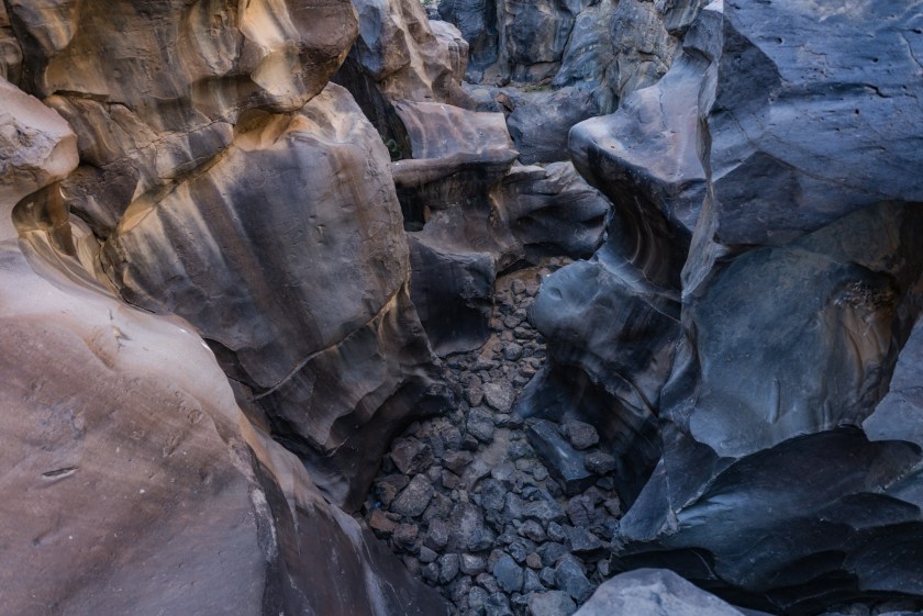
0.3 Miles- From the mouth of Fossil Falls you’ll be treated to what looks like a landscape of polished black lava rock. As you get closer, the sculpted chasm will appear.


Make sure to be extremely careful if you plan on exploring the lower Fossil Falls area. The rocks are smooth, polished, and slick. I wore approach shoes with sticky rubber outsoles and was fine.


Fossil Falls Camping Information:
After enjoying the Fossil Falls scenic hike, you can head back out to explore more in the Sierra Nevada, or call it a night and find a campsite at Fossil Falls. Fossil Falls Campground is managed by the BLM (Bureau of Land Management) like Alabama Hills, and Trona Pinnacles. There are 11 total sites at Fossil Falls, and the area is very rarely crowded. The sites do not offer much privacy or shade, as the landscape is flat, barren, and free of trees. There is a lot of space between the sites though.
After leaving the hiking area behind head towards the ‘U.S Fee Area’ sign and you’ll see a pay station and campground information board on your right hand side.

Each campsite requires a $6 per night fee that can be paid in the lockbox at the entrance. There is a 14-day limit for each stay stay. This is a very minimal campsite, but includes tables and fire rings. There are two main campsite loops, and they are connected by an area with a pit toilet. You’ll want to bring all of your own water, because there is only a hand pump water spout available. You must carry out all of your trash here. The information board lists specifics for each campsite. Not all sites are suitable for RVs.


Driving past the campsite information center and pay station, you’ll see a sign for ‘Site No.1’. The first campsite is located just right of this sign and sits on a large plot. For access to the remaining 10 sites, go left. The dirt access road for these 10 sites is on a washboard road with quite a bit of exposed rock.

You always need to be ready for wind when camping in the desert. It was warm and calm when we arrived at Fossil Falls, but looking north, we could see a massive front of wind and dust moving our way. It wasn’t long until we were getting pushed around by gusts up to 40mph. If you plan on camping in a tent, make sure to pitch it well.

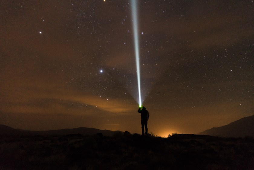
This is also a great area for astrophotography, as the sky is clear with little light pollution. This is also a restricted airspace. The high winds, dust, and sand made for obscured skies on this night though.
Each campsite is surrounded by outcrops of lava rock. We had a lot of fun climbing and exploring here.

Just outside of the main camping area, you can drive right up to the Red Hill cinder cone. Most believe Red Hill last erupted an estimated 10,000-15,000 years ago, but other tests have shown that this date could be as recent as 600 years ago. Red Hill is mined by private enterprise for lava rock and pumice.


Share This Post!

