
The Bear Canyon Trail, also known as Old Mt. Baldy Trail, is one of the toughest routes leading to the 10,064 summit of Mt. Baldy. Gaining 5,848ft in 6.4 miles, this hike requires a solid base level of fitness and a lot of determination.

Directions And GPS Tracks:
- To hike Mt. Baldy via Bear Canyon, drive to 6777 Mt Baldy Rd, Mt Baldy, CA 91759. You’ll park on the west side Mt. Baldy Rd, right outside of the US Forestry Department and Mt. Baldy Visitor Center. Once you’ve parked, walk south towards the Mt. Baldy Lodge Restaurant and go right (west) onto Bear Canyon Dr. You’ll walk on Bear Canyon Dr for .4 miles before reaching the sign for Mt. Baldy Trail.
- Download GPX
- See track on Strava


Key Points:
- Distance: 12.8 miles
- Elevation Gain: 5848 ft
- Minimum Elevation: 10064 ft
- Maximum Elevation: 4266 ft
- Time: 5-9 hours
- Difficulty: (4/5)
- Dog Friendly: Yes, on leash
- Permit Required: No, but an Adventure Pass is required to park
- Parking: Park in Mt. Baldy Village, but do not take up the spaces at the Mt. Baldy Lodge.
- Trail Condition: Steep single track. Treacherous snow and ice in the winter months.
- Cell Phone Reception: Spotty at best
Make sure to hike with the right gear. See my current hiking gear list.
Hike Map And Elevation Profile:


Hike Description:
0.0 Miles (4266ft)- Starting from the Mt. Baldy Lodge Restaurant, head west on Bear Canyon Dr. You’ll be on asphalt for the next .4 miles before reaching the official trailhead of the Bear Canyon Trail (marked Mt. Baldy Trail). You’ll start by passing through the Mt. Baldy Village Church parking lot.


While on the asphalt road, you’ll see the oldest and largest Bigcone Douglas Fir in existence. The Douglas Fir, named ‘Old Glory’, is 173ft tall and 91in in diameter. Old Glory is estimated to be 600-700 years old.

0.4 Miles- The official (Old) Mt. Baldy Trail trail begins here. You’ll see from the trail sign that it’s 6 miles to the summit. This first stretch of trail starts out on a smooth and shaded series of switchbacks that meander near a creek and occasionally provide views out towards the front range of the San Gabriels.


1.8 Miles (5525ft)- You’ll reach Bear Flat. From Bear Flat, you’ll crossover to the south facing base of Mt. Baldy and ascend a series of switchbacks. These switchbacks are steep and seem to go on forever when it’s hot out. Luckily, the views make up for it. As you climb higher, you’ll be able to see the Inland Empire, Baldy Village, and the 3 Ts.


3.0 Miles (7155ft)- At three miles you’ll be finished with the switchbacks and begin a climb up a wide ridge. The three mile point of this hike is marked with a boulder that looks like it’s been hand sculpted.


3.3 Miles (7411ft)- The trail flattens out for a short while to give your legs and lungs a quick break. You’ll see a false peak up ahead that looks like it would be the summit of Mt. Baldy. It’s not. It’s the top of the ridge climb that will take you to the base of West Baldy.

Continue climbing up the ridge towards the summit. If you’re not used to hiking at elevation, this is where you’ll probably start to feel it.


4.7 Miles (9032ft)- Most of the hard work is done at this point, and you’ll reach the top of that false summit I mentioned earlier. This is my favorite stretch of the Bear Canyon Trail, and one of my favorite trail sections in all of the San Gabriels. You’ll start to catch glimpses of West Baldy and Mt. Baldy up ahead. To your right you’ll see Thunder, Timber, and Telegraph, as well as all the peaks in the front range.


5.4 Miles (9478ft)- Only one mile and 600ft of climbing left in this hike. The trail starts to level out, which makes hiking at this altitude very manageable given the terrain you’ve just covered.
5.9 Miles (9782ft)- You’ll reach the saddle between West Baldy and Mt. Baldy. West Baldy is one of those deceptive peaks that looks taller than Mt. Baldy when you’re standing on Mt. Baldy’s summit. It’s not though. West Baldy only adds .4 miles roundtrip to your hike if you’re looking to bag another peak. Catch this one on your way down if you’re going to do it. For now, continue on towards the summit of Mt. Baldy.


6.4 Miles (10,064ft)- You’ll be standing on the 10,064ft summit of Mt. Baldy. Take some time to enjoy the views. Make sure to bring extra layers on this hike, as it can be frigid and windy at the summit, even on hot summer days.


For your hike back down, you’ll take the exact same trail that you hiked up. The only wrinkle will be if you decide to hike up to the summit of West Baldy to bag another peak.


That looks amazing. How often do you go hiking?
Thanks, Alexis. I try to go hiking at least once a week.
That’s great. So do I. Last week I went hiking in Vegas for the first time. Had a blast on Lone Mountain and the Red Rock Canyon.
Awesome. I’ve heard great things about Red Rock Canyon. I’m hoping to make it out there soon.
Yeah, it was great. A bit dangerous, but probably a walk in the park for you. Literally. Haha.
Wonderful post. Your pics always make me want to hit the trails.
Thanks, Miriam! I’m glad to hear my posts have that effect!
Why does it have two names? Mt San Antonio and Mt Baldy?
Mt. San Antonio is the official name of the mountain, but everyone calls it Mt. Baldy. The San Antonio name came from a local rancher in California’s early years. As settlers moved into the area, they referred to it as Baldy because of the barren and treeless landscape of the south facing side that’s visible from the LA/Inland Empire region. It’s a big bald dome that dominates the landscape. I feel like they should just officially change the name to Mt. Baldy, because most people have never even heard the Mt. San Antonio name.
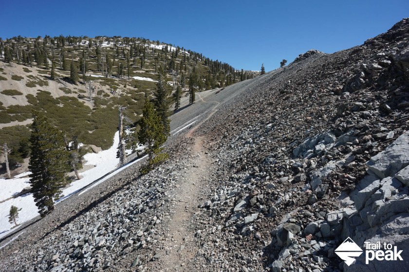
Great hike, Drew. I loved the first pic with the light trail across scree field going out in the distance. Lots of good pics. I’ll make a note of this one; a good one day workout when visiting! Thx.
Thanks, Mike! This is one of my favorite local hikes in the area. Hopefully you can make it out soon to try this one.
sup drew, im pretty familar with Mt Baldy, done it dozen of times and a few times during winter. anyway one approach thats been on my list for quite some time is the north backbone trail from Guffy campground, have you done it from that side? information on it is scarce. ive walked to guffy from highway two but could not locate the Pine Mt trail which ultimately leads to Dawson and then Mt. Baldy.
Hey, Kevin. I’ve never done the trail from Guffy. Like you, it’s been on my list for a while. I’m going to do it this summer once a little more snow melts.
Excellent write up!
Thanks!
Great job Drew. This really helps a lot.
I took part of the annual race to the summit of Mt Baldy about 12-13 years ago. Excruciating but well worth it and wish I had done it again. I’m a really old guy these days (going for the record) but I’ve run/hiked all of my adult life and have been transitioning to trail running this year. As training for my last shot at running a respectable marathon, I plan to hike/run Mt. Baldy again soon on my own.
Question: I want to carry as little clothing as possible so what would be the best time to do this as a runner? June? September?
Thanks and keep up the good work. I an now a subscribed follower.
I’ve run the Baldy Run to the Top a few times. It’s tough, but such a fun race! Starting in June, you’ll be fine with a single outer layer, as long as there is a nice weather forecast Mornings can be cold, but things heat up quickly. July and August are hot almost every day, so make sure to bring plenty of hydration.
I assume the Old Baldy Trail is open again since the storms in 2014? We weren’t able to use it a couple years back.
Yes. It has reopened after the bad flash floods from 2014.
Thanks for the write up and gpx. I’ve been up Baldy 20+ times, did this route today and it kicked my butt. Very humbling lol. Views are gorgeous though, especially on the way down.
Thanks, Tara! This is a great route for sure.