
The abandoned ruin of Bighorn Mine sits just shy of 7000ft on the east facing slope of Mt. Baden Powell. Frances Yarnall, president of the Wrightwood Historical Society offers some pretty fascinating insights on the mine and it’s founder in the Wrightwood Roots. To make a long story short, “Local legend tells us that the mountain man, Charles Tom Vincent…originally discovered the mine, and named it for the sheep he was hunting at the time of discovery.” Charles Tom Vincent was an interesting character according to Wrightwood Roots and other sources. Vincent Gap and Vincent Gulch get their names from the man who helped create what would become the largest gold mine in Los Angeles county. Big Horn Mine has miles of tunnels spanning six levels, and was capitalized for $2,000,000 in 1895. All of this makes for a nice story, but what makes Charles Tom Vincent so interesting is the information he divulged on his deathbead. It turns out Charles Tom Vincent was actually Charles Vincent Dougherty, a man wanted for the murder of three men in Arizona. According to findagrave.com, “His reason for confessing, he said, was to make his real name known so he could be buried in L.A.’s National Cemetery. He had fought in the Civil War, in the 8th Ohio Infantry, and had even been wounded at Chancellorsville.”

Directions And GPS Tracks:
- The trailhead for Big Horn Mine is located at Vincent Gap on HWY 2 (Angeles Crest HWY). This is the same parking lot and trailhead location that is used for hiking Mt. Baden Powell. From the East, hikers can take HWY 15, to HWY 138 W towards Wrightwood. Join HWY 2 before Wrightwood and conintue west towards Vincent Gap. From the West, hikers take HWY 2 from the HWY 210 in La Canada. Click here for directions on Google Maps
- Download GPX
- See my track on Strava
Key Points:
- Distance 4.2 miles
- Elevation Gain 674 ft
- Minimum Elevation 6460 ft
- Maximum Elevation 6932 ft
- Time 2-4 hours
- Difficulty Beginner
- Dog Friendly Yes, on leash
- Permit Required No, Adventure Pass required to park
- Season: Year round
- Trail Condition: Well maintained trail. Well marked and easy to follow.
- You can see my recommended hiking gear here!


Hike Map And Elevation Profile:

Hike Description:
When you arrive to the Vincent Gap parking lot, make your way towards the sign for Mine Gulch and Baden-Powell Summit. If you head on the right hand side with the open trial, you’d join the Pacific Crest Trail towards Mt. Baden-Powell. For Big Horn Mine, head left towards the trail blocked by the white gate. You can walk right around the gate and continue on the fireroad towards Big Horn Mine. There are no postings are signs for Big Horn Mine here, so just continue on this path knowing you’re heading in the correct direction.


Shortly after beginning this hike, you’ll come accross a junction for Big Horn Mine or Mine Gulch Trial. Take the trail on the right hand side towards Big Horn Mine. The trail is mostly still a passable fire road, but gets a little more rocky as the hike continues.


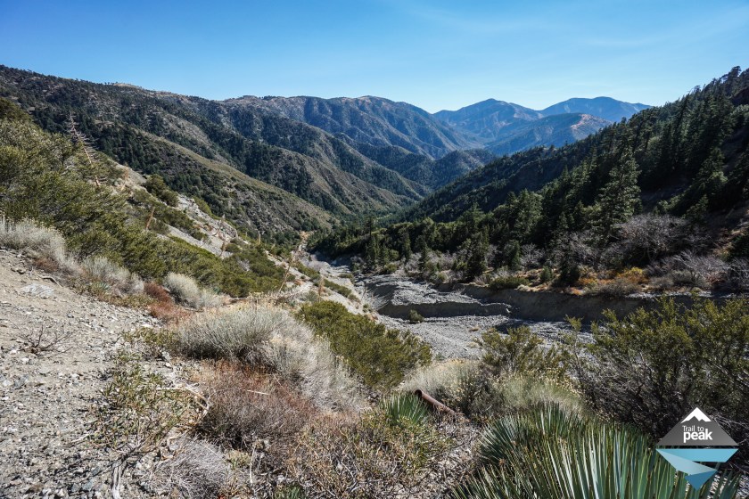
One mile into the hike, the trail turns into a rocky path of single track. After a relatively level beginning, the trail picks up a little bit of elevation in this second half. The views of the surrounding San Gabriels begin to open up, with especially great views of the San Gabriel River Basin.


At 1.35 miles into the hike, we walked right up to a mining tunnel that is located on the trail. Water was flowing out of the tunnel in small stream. There were metal bars blocking the tunnel from entry, but a gap was present that might invite the adventurous types with a body that fits.


At two miles into the hike we began the final uphill push towards Big Horn Mine. I didn’t know what to expect when I first hiked to Big Horn Mine, but I can say with confidence, that the destination does not disappoint. I’m not sure if it’s the history of Charles Tom Vincent, the magic of the California Gold Rush, or the beautiful views of the San Gabriels, but this is one of those hiking destinations that make you want to stick around and explore. The final 20ft of trail towards the mine go down a steep but short downhill section. Be vigilant here and watch your step.


After descending the short but steep stretch of trail to Big Horn Mine, feel free to stick around, explore, and enjoy. Make sure to do so carefully though. This mine is old and falling apart in most places. I crawled up the back path to get a view from the top, and I was not disappointed. There is a large flat open space and the entry of the mine that makes for a great picnic and break location.


Once you’ve spent enough time enjoying the mine and it’s surrounding views, you can return the same way you arrived.
I hope you enjoyed this hiking guide and write up. Feel free to leave me a comment with an questions you might have. Thanks for reading!

“Be vigilant here and watch your step.” I think that’s great all-purpose, everyday advice — but especially for this hike. (YIKES. The vertiginous acrophobe in me was not amused! Ha ha.) But perhaps if I had Lilly and Isla as my guides I’d make it all the way to Big Horn Mine as well. The views really are spectacular! Thank you for yet another wonderful step-by-step guide. Pun intended. 😉
Thanks for reading! Having Isla and Lilly along for the ride makes things a lot of fun 🙂
Having a dog or two along makes almost anything better, doesn’t it? Except canoeing. From hard-won personal experience I don’t recommend canoeing with a dog that is terrified of the water, LOL.
haha, I can imagine that being quite the experience!
NOBODY was happy that day (least of all, the owner of the canoe). 😀
Great pictures as usual, Drew! One of my favorites! Too far though from the west side…sigh..
Thanks! It’s a long drive out, that’s for sure.
I always enjoy your blogs and especially appreciate the elevation profiles that you include. Often the trail guides tell you the beginning and terminus elevation but neglect to tell you that you go up and down several hundred feet several times along the way which does make a tremendous difference in a hike. Great photos and information.
Thanks! It’s one of those things I always look for in a hike write up. That total elevation gain makes a huge difference!
Wonderful photos and great views! Great to know the history behind it too. I’m putting this on my list of places to go! Fascinating!
Thanks! There is a lot of snow up there right now, but this is a great hike to do once it melts.