
This Saturday morning I finished hike number 15/52 for the 52 Hike Challenge in 2015, and have now completed 181.5 of my goal of 1000 miles for this year. Mt. Woodson is a hike I’ve wanted to do for quite some time now. It’s a relatively easy drive to Poway, but the reports of massive crowds have always kept me away. After hiking 55 miles last weekend for the Trans-Catalina Trail, Julia and I decided we wanted to do an easy hike for recovery that we could also bring the dogs on. We were also really excited about the prospects of seeing Potato Chip rock, which is near the summit of Mt. Woodson. This hike is 7.7 miles round-trip with 2100 feet of elevation gained.

The trailhead to hike Mt. Woodson can be found at the edge of the parking area for Lake Poway. The parking lot was already quite full when we arrived, and there were at least 50 people fishing at the lake. There were a few hikers with backpacks getting ready to hit the trail, and I could see others already making their way to the summit. The area around lake Poway is rather beautiful, it’s nice that the trail hugs the water for the first mile or so.

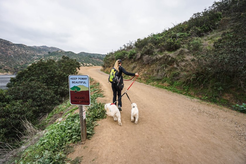
After hiking around the water on the Lake Poway Trail, we came to the intersection for the Mt. Woodson Trail. It was just past this junction that we started seeing how many people make the hike up each day. We were lucky to be starting so early, as the crowds we saw on the way down were far worse.

The trail to the summit of Mt. Woodson is mostly smooth with a few rocky sections here and there. The trail climbs a total of about 2000 ft, but is never really steep. There is only one section of short switchbacks that takes you through boulders and ruble where you feel the grade on your legs. This made it the perfect recovery hike for us, as our legs were still feeling the 25 and 30 mile days we did on Catalina last week. It was also great to be on such a beautiful hike with such spectacular views of San Diego county.


After hiking for about 1 hour and 10 minutes we arrived at Potato Chip Rock and the summit of Mt. Woodson. Even though we arrived fairly early, there were at least 20 people waiting in line to take a picture on the Potato Chip. We were glad to have walked at such a brisk pace while passing so many people. As we waited to take our picture on the chip, the line continued to grow. By the time we left, there were at least 30 people in line, with massive swarms hiking up behind them carrying GoPros and selfie sticks.


We made our way down just as the fog was starting to lift, and the impressive early morning views transformed into something even better. Isla and Lilly always get a little crazy on the downhill as they know the difficult hiking is over, and they can afford to be silly. Isla is still jumping up on boulders and Lilly is starting to do the same. These goldendoodles sure do keep things interesting.
We made it back to the car exactly three hours after we began, and made our way home. This was a great hike for a Saturday morning, and I’m really glad we were able to see Potato Chip Rock and the surrounding area. Due to the immense traffic, I don’t think I’ll ever come back to hike this one on a weekend. A weekday with less traffic on the trail would be far more enjoyable.


Thanks again — I was about to suggest an easy hike in the Laguna Mountains for another recovery weekend then realized it’s 28 miles/ I guess I just want you to take pictures of it 🙂 (and, it’s fun)
Thanks, Martha! I love long hikes, what’s the name of this 28 miler in the Laguna Mountains?
It’s a combination of the Sunset Trail starting at the Meadows Information Station, Big Laguna Trail to the PCT, PCT to Garnet Peak Trail (short and rewarding detour) back to the PCT to Pioneer Mail, trail that leads to Indian Springs Trail (also Champagne Pass, another awesome viewpoint between the Cuyamacas and Lagunas), connect the Noble Canyon Trail back to the Big Laguna Trail and out at Meadows Information Station. I did this on one of those silvery scoured clean December days — it was wonderful.
Wow, this sounds like an awesome hike! I hope to have an equally nice day. I’ll let you know if/when I attempt this one!
One of the best days of my life and it happened spontaneously. My dog (Aussie/Malamute) and I took off in the morning and the day was so beautiful that I kept wanting to see what this place and that place looked like in the light. When it was over, I’d gone nearly 28 miles, was starving and my feet hurt top and bottom but what a glorious hike. VERY beautiful and the whole range of Southern California mountain ecology, from manzanita scrub to Jeffrey Pine, views out to the ocean and to the Salton Sea from Garnet Peak (and Mt. San Jacinto). So yeah, if you do it, I’d love to hear about it.
The pictures are amazing! Looks like a lot of fun!
Thanks!
Potato Chip looks like a very interesting place to visit. Enjoyed your post a lot. Beautiful photos.
Thanks for reading!
Potato chip rock is awesome!
Yes it is!
Another well done hike report, Drew! The day I went out there, it was real foggy, so you couldn’t get a decent picture. But at least we went on a Monday, so the crowds were down. The clarity of your hike photos continue to amaze. Keep up the good work!
Thanks, James! That’s a tough hike in the fog 🙂 I would have loved to hike on a Monday though to avoid the crowds. I’m going to be heading back down there soon, hopefully the weather will be nice.