


The Trans-Catalina Trail is a gorgeous hiking path that spans 37.2 miles over Santa Catalina Island. Situated less than 30 miles from the coast of Southern California, this rocky island makes for a spectacular weekend getaway. The island itself is 22 miles long, and 8 miles across at it’s widest points. Starting in Avalon, the TCT hugs the southeast end of the island before venturing through Catalina’s interior Nature Preserve. The flora and fauna of this section are incredible. Julia and I saw bison, the island fox, and countless birds. The hills are a beautiful green with grasses and coastal sage scrub. After reaching the “Airport in the Sky”, the trail makes it’s way back to the coast at Little Harbor. From Little Harbor, the trail leads you on towards the isthmus at Two Harbors over what I found to be the most beautiful scenery of the entire weekend. Leaving Two Harbors, the trail climbs to it’s highest point before descending to Parsons Landing and leading on to the final destination at Starlight Beach. Below, you will find a map, detailed trail description, and lot’s of photographs!
*Note: We hiked the TCT in two days. Most take three or four, but it’s definitely doable in two if you’re up for it. You can watch my YouTube video below for footage from this trip!


My Trans-Catalina Itinerary:
- Day 0: Long Beach to Avalon via the Catalina Express
- Day 1: Avalon to Little Harbor (~25 miles)
- Day 2: Little Harbor to Parsons Landing and Starlight Beach with a return to Two Harbors (~30 miles)
- Day 3: Safari Bus Shuttle from Two Harbors to Avalon for Catalina Express returning to Long Beach
Transportation:
- To get to Catalina Island, you can take the Catalina Express from San Pedro, Long Beach, or Dana Point. Only the San Pedro location has service to Two Harbors, so keep that in mind for your return ferry.
- We took the Ferry from Long Beach to Avalon for arrival. After we finished the TCT, we took the Safari Bus Shuttle back to Avalon. This was an expensive option. It would have been cheaper and faster to take the ferry from Two Harbors to San Pedro, then an Uber/taxi to our car in Long Beach.

Catalina Express Map

Booking Campsites:
To hike the Trans-Catalina trail, you’ll need to book your campsites well in advance. One reason that we were forced to hike the TCT in 2 days, is that we weren’t able to get camping spots at the sites along the route. In Avalon, you can stay at a hotel or at the Hermit Gulch Campsite. The next stop along the way is Black Jack Campground. From there, you’ll pass Little Harbor, Two Harbors, and Parson’s Landing. You can check availability and book all sites using VisitCatalinaIsland.com.
- Adults are $22 per night from 3/9 to 10/28 and $17 per night from 10/29 to 3/8. Holidays are $24 per night and have a 3 night minimum.
- Children are $13, $8, and $14
- Campfire wood can be purchased at the time of booking. Water needs to be purchased for Parsons and Blackjack. Rangers will place the water in a locker, and you will pick up your locker key from Avalon or Two Harbors.
Distance Between Campsites:
- Avalon to Black Jackjack: 14 miles
- Black Jack to Little Harbor : 7 miles (21 total)
- Little Harbor to Two Harbors: 5 miles (26 total)
- Two Harbors to Parsons Landing: 7 miles (33 total)


Key Points:
- Distance: 37.2 Miles for the TCT. Returning to Two Harbors adds an additional 9 for a total of 45 miles.
- Elevation Gain: ~11,500 ft
- Minimum Elevation: 0 ft
- Maximum Elevation: 1742 ft
- Difficulty: (4/5)
- Permit Required: Yes. You automatically get a permit when you pick up your camping reservation.
- Trail Condition: Lots of fire road and a little single track
- Cell Phone Reception: Virtually none
Gear, Food, and Water:
- Water is available in Avalon, The Airport in the Sky, Little Harbor, and Two Harbors.
- If you stay at Parsons Landing or Blackjack Campground, they will place a 2.5 gallon water jug in your locker.
- The TCT can be very hot and unforgiving. Make sure to always have a few liters of water on you, and take more than you need at each stop.
- Food is available in Avalon, The Airport in the Sky, and Two Harbors. For nights at other campsites, you will need to bring your own food. You will also need to pack snacks along for along the way.
- The gear is fairly standard for backpacking. You can see my John Muir Trail backpacking gear list for an idea of what I usually bring along.
Map and Elevation Profile:


Helpful Links and Downloads:
- Download GPX For Avalon To Little Harbor
- Download GPX For Little Harbor to Starlight Beach To Two Harbors
- TCT Page on the Catalina Website
- Trans-Catalina Trail Map
- DC-3 Airport In The Sky
- Catalina Conservancy Info
- Catalina Express Booking
- Safari Bus Booking
- Catalina Camping Booking

Day 0: Long Beach to Avalon

Julia and I decided to hike the Trans-Catalina trail about a week before departing. This was definitely enough time to step on the trail prepared, but not enough time to book all of our preferred camping destinations. Most people hike from Avalon to Black Jack Campground on Day 1, hike from Black Jack to Two Harbors on Day 2, and hike from Two Harbors to Parsons Landing and Starlight Beach on Day 3, with a return to Two Harbors for Day 4. Unfortunately, there was no availability for Parsons Landing or Black Jack Campground on the days of our hike, so we booked a spot at Little Harbor and Two Harbors instead, and planned on doing two big days. If you’re planning to hike the Trans-Catalina, make sure to book your campsites early.
Getting to Catalina Island is pretty straightforward and doesn’t require as much advanced planning. You can leave from Long Beach, San Pedro, or Dana Point, and arrive in Avalon or Two Harbors. We chose to leave from Long Beach and arrive in Avalon, as that matched our desired itinerary best.

We left on Thursday night on the 5:45 Catalina Express, and arrived in Avalon at 7:00. Our plan was to wake up early on Friday so we could complete the hike to Little Harbor with time to relax throughout the day. To make the morning as easy as possible, we booked a room at the Seacrest Inn, so that we could wake up and get straight to the trail head. If you have plans on a shorter first day and can afford the time, you can stay at the Hermit Gulch campground, which is a 1.5 mile hike from Avalon.
Hiking permits are required for all hikers on the Trans-Catalina Trail. Hiking permits are free, and according to the Catalina Island Conservancy website “can be picked up at Conservancy House in Avalon, the Wrigley Memorial & Botanic Garden, Nature Center at Avalon Canyon, the Airport in the Sky, and the Visitor’s Center at Two Harbors”. If you are arriving late to Avalon like we did, you can pick your permit up at the Atwater Hotel or Pavillion Hotel. The permit is really just a copy of your campground reservation for the first night. When you book your permit, you can pay to have rangers deliver firewood and water to your site. At Blackjack and Parson’s Landing, there is a locker system in use. You pick up your key for Blackjack in Avalon and your key for Parson’s in Two Harbors.

Our room at the Seacrest Inn was a real charmer. What it lacked in size, it made up for in location and feel. We prepped our bags with water, put on our hiking clothes, and laid everything out to be ready for an early start on day one. If you’re leaving from Avalon to the trailhead, you have two choices for your walk to the TCT trailhead. The first option is to walk Pebbly Beach Rd to Wrigley Rd. The option we took was Claressa to Clemente before walking Wrigley Rd to the trailhead. Having looked at the map closer upon returning, I think I would go with Pebbly Beach Rd next time, as the route we took starts off with a steep uphill before losing a good deal of that to drop down to the trailhead. It was a nice warm-up, but an unnecessary climb.
Day 1: Avalon to Little Harbor
Julia and I departed the Seacrest Inn at about 5:15 AM. We knew we would have to walk 3 street miles before reaching the trailhead, and we wanted to time up our start on the official TCT with the sunrise. Things worked out perfectly, and we arrived at the trailhead just in time to see the day breaking over California to the east. It was a perfectly clear morning, with a cloudless sky, and a purple ocean unshackled from the fog you get used to seeing at this time of day. The first few miles follow a wide and smooth fire road without much to make you look down. It was all for the best, as the sunrise kept my eyes fixated on the ascending sun.


After about 6.5 miles on the TCT, we came across the Hermit Gulch Trail Junction. If you’re looking to cut some distance from the total Trans-Catalina, you can hike to Hermit Gulch campground and then continue on to the TCT instead of doubling back and walking to the trailhead.

It was at this point that we started to get really great views of Avalon from high above. Even more special, at about mile seven we saw our first bison! We kept our distance, but worked the angles to get some pictures.


After continuing on we followed the signs to the fist section of trail that wasn’t exclusively fire road. In the followup to hiking this, I read countless blogs and reviews of what to expect. A few complained that the fire road experience was a bit of a buzz kill for them. I think a lot of this has to do with the vehicles that pass by while walking. I think it was a combination of walking on a Friday, and how early we started, but up to this point we didn’t see anything or anyone other than the bison on the trail. The other slight complaint I read about that was completely alleviated at this point was in regards to the trail marking. I’ll put it this way, you have to try to get lost here. Every junction is clearly marked with either a wooden post or a metal stake clearly stating “Trans-Catalina Trail”.


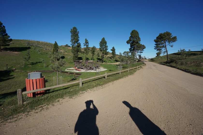
At mile 9 we came across our first opportunity for potable water at the Haypress Recreation Area. This area has benches, BBQ’s, chemical toilets, and a full children’s playground. We found it a great spot to take our first break and refill our water bottles. The water comes from a standard low pressure fountain head that makes it a little tough to refill a smaller mouth bottle, but with a little patience I had my 2 liters ready to go. If you’re just going to Blackjack campground, you only have 5 miles to go from here. If you’re going to Little Harbor, you have 7 miles until you reach the airport and 5 more to Little Harbor, for a total of 12 miles. After we enjoyed our rest at Haypress, we continued on towards Blackjack. The trail marker to rejoin the TCT from Haypress is a little hidden, but if you head towards the children’s play area, veer right and you’ll run right into it.

Right after leaving Haypress we came across a herd of bison numbering about 12. You can really feel the temperature and scenery change as you cut a path through the heart of the island. I was surprised at how beautiful and green everything was. While in Avalon, you can’t help but hear how devastating the drought has been for Catalina. Although it was just a drop in the bucket, the rains that swept through over the past few months have done a great job of at least giving the appearance of a water recovery.


We reached an empty Blackjack campground just after our sixth hour of hiking. I can see why many Trans-Catalina hikers make this their first stop. It’s a great location for a first nights campsite, and if we were one of the groups who couldn’t start until late in the day, the timing would have been about perfect. Lucky for us, we were able to get up early, and with lunch right around the corner, the only thing I had on my mind was a bison burger from the airport!

The climbs just before Blackjack campground were some of the steepest of the day, but luckily only one more stood between us and the airport. We made our way downhill past a water tower to the left of the trail and began a descent with the airport in view. It’s important to note, that you cross Airport Rd at this point. If you’ve had enough of the trail and don’t want to do another climb, you can stick to the road and head straight to the DC-3 Grill. As we left the road and moved along the trail, I suddenly heard the pounding of hooves and a flash of brown fly in front of me. I looked up to see Bison on both sides of the trail. There were 23 in total.

After walking past the bison, we got to the final stretch of trail that takes you past the soap stone quarry and exhibit labels. I wish I would have spent more time reading, but it was lunch time and I was hungry. We walked around the airport a little before entering the DC-3 grill, where I ordered a bison burger, bison dog, and cold glass of lemonade. The meal was pure heaven!


There isn’t much to note about the trail leading away from the airport and into Little Harbor other than the fact that’s it’s all downhill and it’s all fire road. One notable moment was when an island fox jumped from a bush and scampered away faster than I could raise my camera. We made it to Little Harbor right around 3 PM and settled in for a wonderful evening. This is a beautiful campground, and our selection of site #11 turned out to be perfect as it was just on the water. From our tent we could see and hear the waves crashing in the harbor as the sun set on the horizon.
For those looking to book here on the TCT, you can reserve firewood when booking your reservation. There is potable water and chemical toilets on site. There is no ranger present in the winter, but the area gets cell service so you can call Two Harbors if the need arises.

Day 2: Little Harbor to Starlight Beach to Two Harbors
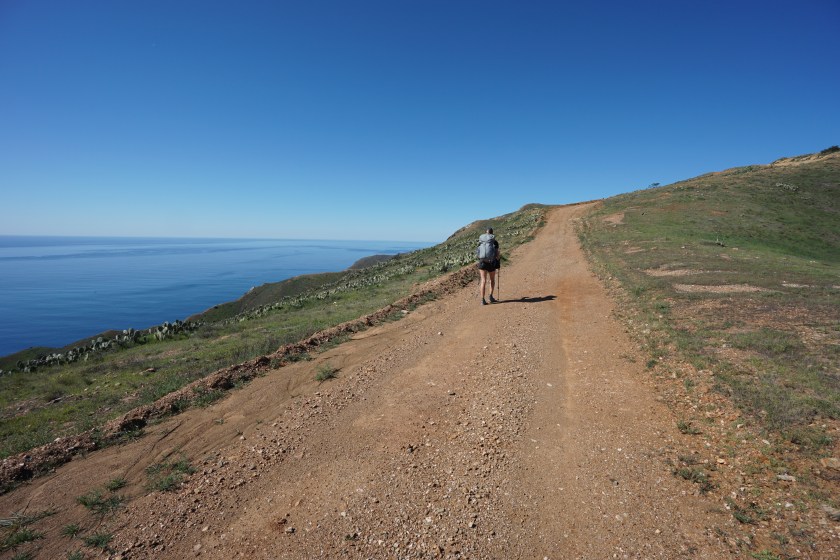
Day two started off with what I found to be the most beautiful section of the TCT. Beginning with an uphill climb out of our campsite, the views of Little Harbor and the Pacific Ocean were nothing short of breathtaking. A dirt path lined with cacti, wooden posts, and rusted barb wire made for the perfect backdrop for the sun rising up over the horizon.


It was at mile 23 I began to realize just how phenomenal this island can be. Everywhere I turned was unmatched beauty, and every view was one I wanted to last forever. At around mile 25 we reached a covered bench which also marked the end of the major uphill hiking. Make sure to pace yourself on this uphill. There are three main pushes, and each one gives you the impression that it will be the last.


The downhill from the covered bench took us straight into Two Harbors, with the main harbor on the right and the smaller harbor on the left. The trail continues straight before veering left around the smaller harbor, but we took a right to check in at the Two Harbors visitor center and confirm the reservation for our campsite in town. There are restrooms, water, food, and a restaurant in Two Harbors, so make sure to grab what you need here.


It wasn’t long before we were back on the trail and hiking up this surprisingly steep section of the TCT out of Two Harbors. Much like the section in the morning, I hardly noticed the grade of the climb, as my mind was too preoccupied with all of the surrounding beauty.

As the climb ends and the downhill to Parson’s Landing begins, the trail splits with an option for Silver Peak. I think I’ll take a left at the junction next time to Silver Peak and go straight to Starlight Beach, as it seems to be a nice addition while cutting out some distance. This time, we took a right at the junction and continued on the TCT to Parsons landing while staring at the waters and wishing there had been campsite availability here!

The final stretch from Parson’s Landing to Starlight Beach looks pretty straightforward on the map, but don’t let this deceive you. The trail turns into a roller coaster with lot’s of changes between uphill and downhill, some rolling, while others are very steep. It was a welcome mental challenge though. Sometimes it’s nice to stroll to the end of a great adventure, but this one makes you earn it the hard way.


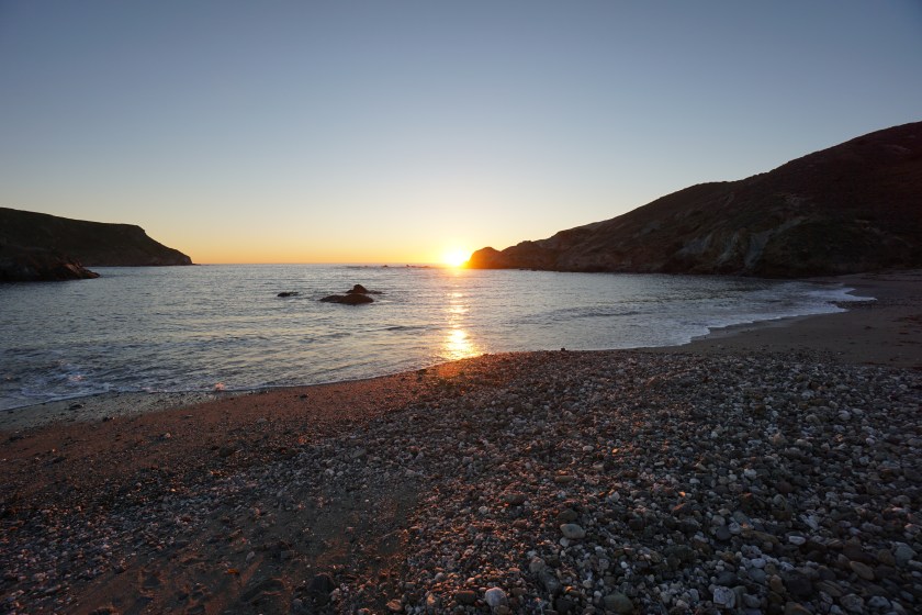
The final section of the TCT is a steep section of road leading down to the coast. The mind acts funny when it knows the end of something is near. Part of me was wanting to slow down, the other part was pushing me to sprint. We made our way around the final turn, and after two days of hiking, we made it to Starlight Beach!


On the way back we continued on West End Rd past Parson’s Landing instead of taking the Trans-Catalina back to Two Harbors. It’s a smooth and flat fire road with ocean views the entire way. My favorite part was passing through Cherry Cove, it was at this camp I first got to explore Catalina. I was in 8th grade then. The sun was just setting as we made our arrival back to Two Harbors. Our first stop was at the Harbor Reef Restaurant to get some dinner. It was the perfect ending to the perfect day. After dinner, we made our way up to the campsite, got the fire going, and relaxed to the crackling sound of burning wood while watching the boats bob in the harbor.


Day 3: Two Harbors to Avalon
After spending a pleasant evening of deep sleep, we woke up a bit later than usual before heading back to the restaurant in Two Harbors to grab some breakfast. A light fog was rolling over the area from the Southwest, and the views were nothing short of perfect. We took a stroll along the beach and made faces with a local dog before catching the Safari Bus back to Avalon.


