
Falling Rock Canyon is a strenuous Class 2 off-trail hike accessed from the Icehouse Canyon trailhead. Falling Rock Canyon is the main access point for hikers looking to summit Sugarloaf Peak. Do not attempt this hike if you do not have adequate off-trail backcountry hiking skills, equipment, and ability. Hiking can be dangerous and deadly if proper precautions are not taken. In this guide, I will provide photos, maps, a GPX file, and a trip report for a hike of Falling Rock Canyon to Sugar Loaf Peak and Ontario Peak.

Directions And GPS Tracks:
- The trailhead to hike Falling Rock Canyon is located at the Icehouse Canyon parking lot. Click here for directions
- From the 210 freeway, exit Baseline (eastbound) or Mountain (westbound) and head north towards Mt. Baldy Road and Mt. Baldy Village. Continue past Mt. Baldy Village for around 2 miles until you reach a fork. You’ll see the parking lot for Icehouse Canyon on the right leg of the fork.
- Download GPX
- See track on Strava
Key Points:
- Distance: 9.5 miles
- Elevation Gain: 4039 ft
- Minimum Elevation: 5131 ft
- Maximum Elevation: 8694 ft
- Time: 5-9 hours
- Difficulty: (4/5)
- Dog Friendly: No
- Permit Required: No, but an Adventure Pass is required to park at Icehouse Canyon Trailhead.
- Parking: There is a parking lot at the trailhead, but it fills up by 7:00 AM on most weekends. Additional parking is available along the road. Be prepared to walk upwards of 1 additional mile if you arrive later than 8:00 AM.
- Trail Condition: Falling Rock Canyon is a mostly Class 2 affair. There is a lot of loose talus and scree. The trail is very steep and technical.
- Cell Phone Reception: Virtually none
Make sure to hike with the right gear. See my current hiking gear list.
Hike Map And Elevation Profile:


Hike Description:
0.0 Miles (5131ft)- The hike for Falling Rock Canyon begins at the Icehouse Canyon trailhead.


0.5 Miles (5456ft)- When you reach the first established switchback, look for a use trail to the right. If you’re not looking for it, it’s easy to miss.


After leaving the Icehouse Canyon Trail you’ll cross a creek and head east past two old cabin foundations. When you pass the second foundation, look to your right (south), and you’ll see the entrance to Falling Rock Canyon.


Falling Rock Canyon starts out very gradually and allows for very secure footing. At 0.65 miles you’ll reach a seasonal waterfall (usually dry) that requires the use of hands and a little climbing to continue up the canyon.


Once you’ve hiked up and over the falls, you’ll see where Falling Rock Canyon gets it’s name. If you’re hiking in a group, make sure to keep your distance here, as every step can send rocks and pebbles cascading down behind you. The left hand side of the canyon has some nice solid rock if you want to do a little climbing. The right hand side of the canyon is a little more gradual, but the terrain is very loose underfoot.
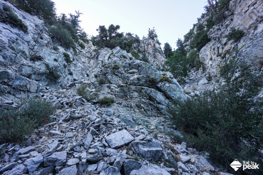
1.0 Miles (6267ft)- This is a very important turnoff point for the hike to Sugarloaf Peak. When you reach the 1 mile mark, the canyon splits in two. You’ll want to head right at the ‘V’ to continue towards the saddle for Sugarloaf Peak.
The talus on this stretch can be deceptive, so be careful with your footing. There is a lot of solid rock to hike on, but a lot of it sits on soft earth that can move with your weight.


1.4 Miles (7014ft)- After climbing the talus field out of Falling Rock Canyon you’ll reach the saddle that sits behind Sugarloaf Peak. At first the path to the summit looks obscured by growth and brush, but push through and you’ll find a use trail that heads to the summit block.

1.6 Miles (7021ft)- There is a small plastic register can with a notebook and pen at the summit of Sugarloaf Peak. Needless to say, there aren’t a ton of signatures. At this point, you’ve climbed nearly 2000ft in 1.6 miles. Hopefully your legs still have some energy, because there is a lot of climbing left to do.
Looking to the east, you’ll get a view of Ontario Peak and the uphill climb that awaits. When you’re ready to proceed, head back towards the saddle, and locate the use trail that approaches the ridge to Ontario Peak.


The trail leaves the Sugarloaf saddle at a fairly gradual grade. Enjoy these fleeting moments of reprieve, because things get steep with a quickness. There is a use trail on both sides of this ridge. I find the trail on the right hand side is a little easier on the legs. There are a few rocky outcrops that slow things down, but the path isn’t too difficult to follow. There are also a few cairns to make sure you’re heading in the right direction.


The final stretch up the ridge to Ontario Peak is one of the steepest of this hike, but it has some of the best hiking terrain underfoot which makes the paces tick by pretty quickly.


3.0 Miles (8215ft)- The terrain levels out substantially when you leave the ridge route behind. You’ll get to walk through an old burn area that is really starting to come back to life. Wild berries grow like mad up here. It’s also pretty common to spot dear and bighorn sheep in the area.
The only downside to this section is that the brush obscures any clear walking paths. There are a few use trails to be found, but a little bushwhacking is necessary. I’ve found that hiking on the crisscrossed fallen trees allows me to move quickly. Just make sure to be very careful not to step on rotting wood.

3.4 Miles (8583ft)- You’ll reach the official trail to Ontario Peak and you’re off-trail journey has come to an end. It’s only a short walk to the summit of Ontario Peak from here.


3.6 Miles (8696ft)- Ontario Peak provides some amazing views of the Inland Empire on a clear day. Right in front on Ontario Peak you’ll see a ridge that leads to Turtle’s Beak. To the east you’ll see Cucamonga Peak, San Gorgonio, and San Jacinto. To the south you’ll see Santiago Peak. To the west you’ll see Catalina Island and the Pacific Ocean if the weather cooperates.


For the hike back to the starting trailhead, I suggest the standard Ontario Peak trail to the Icehouse Saddle and Icehouse Canyon Trail. It is possible to hike back down via Falling Rock Canyon, but those loose scree fields require a lot of care while descending.
I hope you’ve enjoyed this guide of Falling Rock Canyon to Sugarloaf and Ontario Peak. Feel free to leave me a comment if you’ve hiked this one, and/or ask me a question if there is anything I didn’t cover.
Thanks Drew. I’m planning on doing this hike this weekend. Your pictures and description is very helpful.
I’m glad you found this guide useful. Have fun! It’s a great hike.
Excellent report and vital information. My group will be hiking this exact route on May 12th. Your instructions will help us out a lot. Do you have similar instructions for Icehouse Canyon to Cucamonga, Etiwanda and Big Horn. Exiting out through Kelly Camp, Icehouse Saddle, and Icehouse Canyon. Thanks Drew
Thanks, Philip. I’m glad you’ve found this useful. I don’t have a full write up of that hike yet, but I’ve done it a few times. Here is a link to my Strava track (https://www.strava.com/activities/246291887). If you want the GPX data, send me an email and I’ll forward it along. It’s a pretty straightforward route though. After bagging Etiwanda and Cucamonga, you’ll descend Cucamonga until you reach that saddle. From there, a use trail climbs up to Bighorn.