
The hike to Big Pine Lakes via the North Fork Trail is a great way to see the beauty on display in the Sierra Nevada mountains. Starting at the Big Pine Creek Campground, this trail passes by Mt. Alice, before entering the John Muir Trail Wilderness of Inyo National Forest. There are 7 Big Pine Lakes, numbered sequentially. For this hike, we only visited the first three, as snow and ice were blocking the trail for lakes 4-7. The first three lakes are known to be the most scenic, as they sit with the majestic Temple Crag in the background.

Directions And GPS Tracks:
- The trailhead to hike the Big Pine Lakes Trail begins at the Big Pine Creek Campground. Click here for directions.
- Take HWY 395 to the city of Big Pine, CA, which is located just south of Bishop, CA. From Big Pine, head West on W Crocker Ave. W Crocker Ave will become Glacier Lodge Rd. Stay on Glacier Lodge Rd until you reach the trailhead.
- Download GPX
Key Points:
- Distance: 11 miles
- Elevation Gain: 2848 ft
- Minimum Elevation: 7814 ft
- Maximum Elevation: 10,291 ft
- Time: 6-10 hours
- Difficulty: (3.5/5)
- Dog Friendly: Yes
- Permit Required: Not for hiking, but a permit is required for backpacking overnight.
- Parking: There is a small parking lot at the trailhead that fills up pretty quickly on summer weekends. There is an overflow lot nearby and parking along the street as well.
- Trail Condition: This is a steep and rocky trail. There are a few creek crossings that can run pretty high depending on the season. The first half of this trail is fully exposed and can be very hot in the summer.
- Cell Phone Reception: None.
Make sure to hike with the right gear. See my current hiking gear list.
Hike Map And Elevation Profile:
Hike Description:
0.0 Miles (7814ft)- Starting out at the Big Pine Creek Campsite, the asphalt road will dead end when it reachers a metal swing gate. Past this swing gate, you’ll see the trail and a few cabins with green roofs.


The Big Pine Creek will be flowing to your left, and shortly into the hike you will pass a bridge. This hike was completed in 2017 after a year of heavy snow. The snow melt was pretty spectacular on this day, which made for a very fast moving creek.


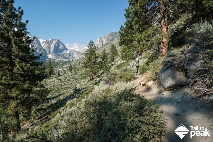
0.25 Miles (7907ft)- You’ll reach the junction of the South Fork and North Fork trails. Head right at the fork to take the North Fork Trail. You’ll hike a few shaded switchbacks before the views start to open up.

The trail then gets quite a bit of tree cover before once again passing by the banks of the creek. This is a nice spot to stop on the return leg of this hike.


0.7 Miles (8196ft)- You’ll reach a dirt flat blocked by wooden posts. Take a right turn here. You’ll soon cross over a bridge and enter a sandy stretch of trail that picks up in elevation gain.


1.6 Miles (8576ft)- As you climb the long switchbacks of the North Fork Trail, make sure to look back and enjoy the views in your ‘rear view’.


2.0 Miles (8924ft)- You’ll pass into the John Muir Trail Wilderness at the two mile mark of this hike. After passing the John Muir sign, you’ll hike along the creek on a rocky stretch of trail. At the top of this rock stretch along the creek, the trail enters a lush forest. The mosquitos can swarm in a quickness at this point, so make sure to come prepared.


2.7 Miles (9196ft)- You’ll pass by the Big Pine Creek Wilderness Camp on your left and Lon Chaney’s Cabin. The climb continues up towards Big Pine Lakes and Temple Crag with the Sierra views becoming ever more prominent.


4.30 Miles (9968ft)- You’ll see a trail sign posted on a tree that points to Lakes 1-7 or Black Lake. When the trail conditions permit, it is possible to do this a loop hike. When doing the loop hike, you’d hit the Big Pine Lakes first and then return to this point via Black Lake. For this guide, we’ll just be heading left at the junction to Lakes 1-3 and returning for an out-and-back hike.

4.45 Miles (9980ft)- You’ll be near the banks of Big Pine Lakes 1. If you continue on the trail you’ll gain elevation for a nice view high above the lake. If you want to walk down to the lakes shores, make sure to turn left through the woods when you see the No Fires sign.


The first Big Pine Lake is a great place to stop for lunch and a rest before continuing on to Big Pine Lakes 2 and 3. Once you’ve spend enough time soaking up the views of Big Pine Lakes 1, head back to the trail the same way that you arrived and continue heading uphill. You’ll get to see more of Big Pine Lakes 1 from the trail.


5.1 Miles (10138ft)- Big Pine Lake 2 is just a short hike from Big Pine Lake 1. The trail is pretty rock here, so watch your footing. There are a few areas where hikers can make their way down to the shores of Lake 2, but after a long stop at Lake 1, we were happy to see this lake from above.


5.5 Miles (10283ft)- Leaving Big Pine Lake 2 behind, the trail climbs up towards Lake 3 on a gentle rocky outcrop. The distance between Lake 2 and Lake 3 is just .4 miles. Like Lake 2, there are a few ways to reach the banks of Lake 3. We were content with viewing the lake from above though.


Big Pine Lake 3 was the turnaround point for this hike. You can also continue on the trail towards Big Pine Lakes 4-7 and Black Lake for a loop hike if the trail is clear.
That looks amazing!! I so need to get out that way for some hiking.
I hope you can make it out soon!
Headed out there this weekend! How were the mosquitoes up at the lakes? I’m getting conflicting info.
The mosquitos were swarming pretty thick on our trip!
Just stunning, and as usual, the organization and information provided in this post are excellent.The family shot at the lake is great.
Thanks, Caroline!
Thanks for a nice report. I was up June 21-24 and the trail to Lakes 4-7 were impassable without snow shoes. Mosquito’s were not too bad. I’m heading up again Sept. 17-21 or 24-28 depending on weather.
Thanks, Ed. Let me know how things are looking when you return later this month.
Great pics! How long dis it take you guys to get to 2nd lake? Me and my wife will be doing the trail this coming sunday but we will be starting out late, around 12noon. Will we be able to get to 2nd lake before night?
Thanks, Gerard. Sorry for my delay on the reply. Starting at noon should give you enough time. You’ll have 6+ hours of daylight. Our out and back hike only took 7.5 hours, and that was at a very leisurely pace with breaks.
Hey! That looks amazing! my friend and I would love to do it this weekend but since we are only in LA for 3 months, we dont have tents and were thinking of staying in a hotel and do a 2-day hike. what do you recommend?
I’m not sure what you mean by a two day hike, as that would require a tent. You can day hike this trail if you’re able to do so before the first few snow storms hit.
Nice detail! Very helpful post and beautiful pictures of the hike! Just to confirm, was it 6-10 hours just to Big Pine Lake 3 and back? or an estimated 6-10 hours for all 7 lakes roundtrip ?
Thanks. Yes, that is for lakes 1-3 roundtrip. Your miles may vary.
Hello,
I realize the first half of the trail is not shaded. If i am planning to backpack in July, what time would you suggest i start hiking to avoid the worst of the sun, during this part of the trail?
I can’t really say without knowing your fitness level and hiking pace. To be safe though, a pre-sunrise starting time would ensure you won’t be hiking uphill in the heat of the day.
We absolutely loved this hike! Great detail and info on this post 🙂 Also, love the photos and that you brought your pups along!
It’s a great hike for sure. Our dogs love anything in the Sierra.
What date did you perform the Hike? Think the trail to the first 3 lakes would be open by mid May?
The hike was completed in July after a year of heavy snow. There is no way to say if the first three lakes will be accessible on a snow/ice free trail. We’re expecting a few more storms this Spring that look to dump quite a bit more snow in the Sierra. Mid-May might be a bit too early for it to melt.
A friend of mine was just out at Big Pine lake 2 weeks ago and although there was some snow on the ground they were able to get out there. They brought micro spikes and used them minimally. Like OP says though, there will be more storms in Sierras during the spring and that usually means snow in the backcountry. Just be prepared for all the conditions and you should be fine 🙂
Can you hike lakes 1-3 at the end of May?
It really depends on the snow from year to year, as well as your experience and ability. Early May can have snow and ice on the trail for lakes 1-3, but each year is different. Call the ranger station and verify before hiking.
We will be going there June 1st, in preparation for Mt Whitney climb, so excited. Thanks for all the pictures and information.
You’re welcome!
Thank you so much for the great info! I’m planning on solo hiking Lakes 1-3 over Memorial Day weekend. Besides the typical vantage points, any other recommendations for unique photo opportunities?
You’ll see plenty just off of the trail!
what month did you hike? thanks
Sunday, July 2, 2017
Did you bring a bear canister with you out there? How do you recommend storing food?
We only did a day hike. If we camped overnight, we would absolutely have a bear canister.
I saw you brought your dogs. What’s the pet policy for this backpacking trip?
They are allowed. Just makes sure you come prepared and your dogs are in shape.
It seems like it was amazing trip. I am planning to go this weekends, but it will be my first hiking, and I am afraid of wild life like bears. Is it possible to see bear or such kind of animal? Thank you!
Just got back from hiking this trail. I’m still in awe of the views. I loved it. Thank you for sharing this information!
It’s an amazing hike. Glad you enjoyed it!
Would it be a good idea to hike this trail in mid October?
It depends on the year and on the weather.
hi! I’m thinking of doing a solo hike on Sep 26. is it easy to get around for a female going alone?
Impossible for me to answer without knowing your experience and fitness level. The trail is pretty easy to follow though if that is what you’re asking.
yes, it is! thank you!
Planing on going here in mid October. Not in a good shape as I used to, but I’ll defy the odds lol. Bringing my dog too. Wanted to camp so I could take some astrophotography pictures, but permits are limited until the end of October, which I think it’s when the storms may start. Thanks for the Guide OP!
Each year is different. Some years, it will be nice until mid November! Good luck!
Hi! How did your puppers do on this hike considering it is at higher elevation? Did you guys acclimatize the day prior at all? Thinking of taking our dog on this hike but unsure if we have to take any extra precautions due to the high elevation. Thanks!
They did fine and we didn’t need to acclimatize. I take them on hikes up to our local 9,000ft+ peaks quite regularly, so they’re not your average hiking dogs (despite their size!). Don’t let this be your dogs first hike at altitude and/or on rocky terrain. Get some elevation training in first and toughen up their paws. My dogs don’t like booties, so we use Musher’s Secret. It works really well.
Thank you so very much for all this information !!!!! We camp at Big Pine every year but so far have only casually hiked to the second waterfall. This year we are going in mid June and planned to get to the fifth lake. After reading you amazing story I dont think we are going to make it due to snow and ice. If you went last year on July second and you were blocked then I am sure we will be during mid June this year. It is acually snowing right now there .Thank you again for so much information and allowing me to plan my trip accordingly !!!!!
There will still be snow and ice on the trail in mid-June this year based on the current snow pack, and it will probably stick around until August.
Hi there! Is it unsafe to currently hike to the Big Pine Lakes? We were planning the hike for this Sunday, 5/26, but it looks like it’s still snowing in the area. Both Friday 5/24 and Saturday 5/25 are projected to be sunny though, if that might help melt some snow. Has anyone done the hike recently who can share their experiences?
Yes, it is unsafe and I would strongly suggest you do not go this weekend. These storms are dropping a ton of rain and snow. This is on top of an already huge year for snow.
Heyo! Great info; much appreciated. Planning to head up in little over a week from now- do you think lakes 1-3 will be accessible then? Thanks!
You’ll want to call the ranger station.
Hey hey! We’re planning to go in a little over a week from now and came across these updates https://www.alltrails.com/trail/us/california/big-pine-lakes-trail — jic this is helpful to you! Looks like they are but still pretty snowy
Thanks for the link. This will be an interesting year due to the heavy snowfall.
Awesome blog! Just booked me a campsite for mid June and have been wanting to do this hike since moving to California five years ago. Your pictures look amazing. What app do you use to track your hike with the 3D model?
Thanks, Tim. Hopefully you’ll be able to go with the current Covid situation. I use my Garmin to track and Google Earth to plot.
Great post! Any recommendations on best campsite? Thinking of an overnight backpacking trip.
No ‘best’ camp site in a place like Big Pine Lakes. They’re all pretty nice.
I hiked this trail with my family every summer growing up … I am now in my late sixties. It’s an amazing area.
Sounds like a great way to spend the summer as a kid!
Thank you so much for putting this blog post together!!
I did this with my boyfriend just last week. The hike up was definitely a challenge but it was soooo worth it especially with the views. We went to have quick lunch at lake 1 and then saw lake 2 and went down closer to it to set up our new hammock. After relaxing and jumping in, we checked out lake 3 for a quick 10 mins and then ran down the mountain, which was a lot easier than going up. That is for sure!
Thank you so much for posting this blog! I am 15 weeks pregnant and will be attempting this with my 17 month old daughter next week. I loved seeing you out with your Osprey Poco packs. We have the same one and love it. How did you little one’s do? Did the altitude affect them? Where did you stay the night before hiking? What time did you hit the trailhead? Thanks again in advance!
This brings back great memories. Hiked this back in 2005 to 2nd lake.