
Chino Hills State Park is a 14,173 acre park located on the borders of Orange, Riverside, and San Bernardino Counties. Visitors to Chino Hills State Park can explore 60 miles of trails and fire roads that pass through woodlands, sage scrub, grasslands, and wildflowers. One of the most popular hikes within Chino Hills State Park is the Bane Ridge Trail. This hike covers 4.8 miles with just under 1000ft of elevation gain.
Getting There: Directions And GPS Track
- The trailhead for this hike can be reached via Bane Canyon Road near HWY 71. As you enter the park from Bane Canyon Road, you will pass the park kiosk to pay the $5 entry fee. From there, you will drive for 5-10 minutes before reaching a hairpin turn with a dirt road on your right.When you turn on to the dirt road you will see a loop parking area for horse staging. You can see how the trailhead begins from the staging area in the photo below.
- Use the Google Maps link here for exact directions from your location: Chino Hills, CA 91709
- Download GPX
- See track on Strava

Hike Profile
- Distance: 4.80 miles
- Elevation Gain: 978 ft
- Minimum Elevation: 767 ft
- Maximum Elevation: 1171 ft
- Time: 1-2 hours
- Difficulty: (2/5)
- Dog Friendly: No pets allowed in Chino Hills State Park
- Permit Required: No
- Parking: $5 entry fee to park in Chino Hills State Park
- Water: No water sources
- Weather: Very hot in the summer months, only advisable from September to May. Do not attempt this hike without plenty of water.
- Trail Condition: This trail is mostly single track with a few steep rocky patches
- Cell Phone Reception: Very good
Do you have the appropriate gear for this hike? Don’t hike unprepared!
See my current hiking gear list.
Hike Map And Elevation Profile
Hike Description:
0.0 Miles – Starting from the horse staging area, head towards the fire road at the north end of the parking loop. The trail begins with a gradual uphill and you’ll see the signage for Bane Ridge Trail. There are restrooms located at the trailhead, so make sure to stop here before hitting the trail.


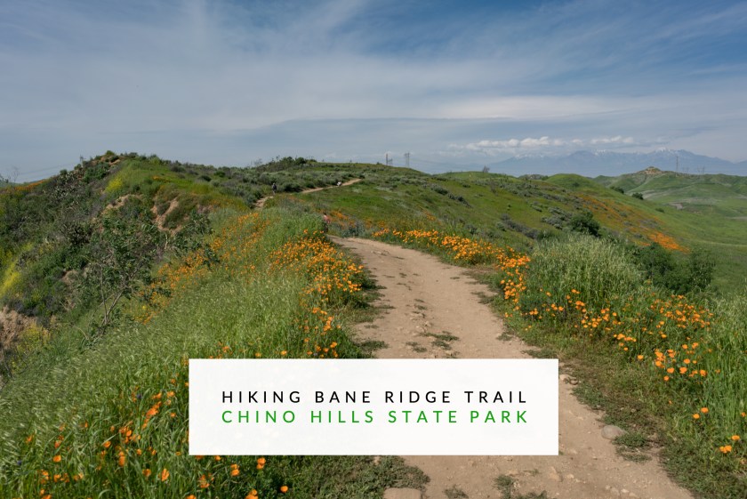
Bane Ridge Trail quickly leaves the fire road behind and starts out on a rolling single track. The grass can be high and thick here depending on the rainy season and time of year. Make sure to stop and look back behind you to enjoy the views on the other side of Bane Canyon.


Chino Hills State Park is also a great place to see wildflower blooms in the springtime. You won’t see the same concentration of poppies here that are on display in Lake Elsinore, but there are far fewer people here as a trade off.


1.0 Miles – As you complete the first mile of hiking, you’ll pass under a pair of transmission towers with cables running overhead. The singletrack trail will continue to roll amongst the green hills from here.


2.0 Miles – As you approach the two mile mark, you’ll see a sign for Bane Ridge Trail and for the Sidewinder Trail. Continue straight ahead due north at this junction to stay on the Bane Ridge Trail.

After passing the junction for Bane Ridge and Sidewinder, you’ll see a pair of peaks up ahead. As tempting as these peaks are to climb, the area is currently listed as closed by the state park authorities.


2.4 Miles – When you see a yellow gate and an asphalt road you’ll have reached the end of this hike. You are now on Bane Canyon Rd, which is the same road that you drove on to get into the park. Turn around here and hike back to the trailhead on the same path with which you arrived.


How beautiful Drew! And my kind of trail. Thanks for sharing your experiences out on the trail!
Thanks for reading!
Those wildflowers 😍😍 what a great pop of color. Looks like an interesting little hike!
It’s a special time of year here! Wildflowers are everywhere!
are the wildflowers expected to be there 5/? If not, where in santa ana would you recommend for a wildflower hike?