
Tour du Mont Blanc (TMB) is one of the most popular long distance hikes in Europe. Starting out in Chamonix, France, the TMB passes through Italy and Switzerland before returning to France. The trail encircles the Mont Blanc Massif in a 170km (106m) loop. Along the way you’ll see snow capped mountain peaks, glaciers, and pristine valleys. You can choose to camp, or do as we did, and stay at mountain huts or bed-and-breakfasts. If you’ve ever wanted to see the Alps, this trail will give you an up close and personal tour of some of it’s best views. Here are 18 photos that I hope will make you want to hike the Tour du Mont Blanc!
1.) The Tour du Mont Blanc begins in the French commune of Les Houches, just 6km from Chamonix. We stayed at Gite Michel Fagot, and met quite a few hikers on the night before our journey began. The views from Les Houches are quite amazing, and whet the appetite for the days to come.

2.) Leaving Les Houches on the first day, I got to see how well marked the TMB is. There are trail signs at nearly every junction. It is almost impossible to get lost. Just look for the green TMB logo and you’ll be on the right track.

3.) Our first night was at L’hôtel Gai Soleil in Les Contamines. The photo below was the view from our bedroom window.

4.) From Les Contamines, we hiked up towards Col de la Croix.

5.) The views up at Col de la Croix were pretty amazing.

6.) On our way towards Les Chapieux, we approached the Refuge de la Croix.

7.) Refuge de la Croix sits at just over 8000ft of elevation and is open to hikers from June to September.

8.) The hike out of Les Chapieux is one of the most beautiful stretches on the TMB. On this day you’ll pass up and over Col de la Seigne and cross the border from France into Italy.

9.) Be ready to experience all four seasons on the TMB, sometimes you can get a few seasons worth of weather in one day. After a sunny morning in Les Chapieux, we had rain and light snow on our descent to Courmayeur.

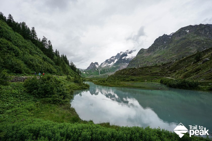
10.) One of the highlights of the hike from Col de la Seigne to Courmayeur is the stunning Lac Combal.
11.) We were incredibly happy to make it to Courmayeur after hiking through miles for a cold rain. Courmayeur is one of the premier skiing destinations in Italy and has some really nice shops and restaurants.

12.) As hikers climb up and out of Courmayeur, they’re treated to some pretty amazing views of the city and the surrounding mountain range.

13.) As you hike away from Courmayeur on the TMB, views of Mont Blanc and the Aiguille Noire come into view from Rifugio Bertone. We had more of a drizzle with low visibility as we hiked, but still got to see the lush green single track on our way to Chalet val Ferret.
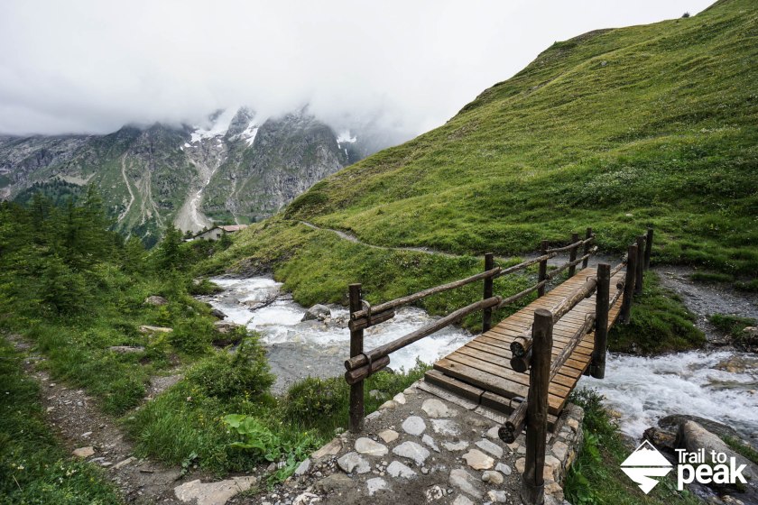
14.) The TMB is an incredibly well developed and organized trail. Unlike the John Muir Trail, no water crossings are necessary as bridges are placed over areas with running water. This allows hikers to stop on the bridges and take in the views.

15.) As I mentioned above, you can experience all four seasons on the TMB. As we passed over Grand Col Ferret and left Italy for Switzerland, we got caught in a brief snow storm in the middle of July. Luckily the weather wasn’t that cold, and the snow melted quickly as we descended into La Fouly.

16.) I enjoyed every night we spent on the TMB, but few views compared to the one we had at Champex Lac. Looking out onto the lake from our room made for a very special evening.

17.) There is one main Bovine Trail on the TMB, but many could be listed as such. The cow patties mixed with rain and mud made for some less than stellar smelling trail shoes at the end of a long day. On the hike from Champex Lac to Trient, this cow chimed it’s bell as we passed along.

18.) Our final day on the TMB was a washout with slow miles in the rain and mud. Luckily, the sun began to shine and we were greeted with blue skies the following day in Argentiere.

You can see more about each day on the Tour du Mont Blanc by visiting my Tour du Mont Blanc page!
Your pictures perfectly display the beauty along the TMB. I completed the hike last summer so it was nice to reminiscence about my trip as I viewed your pics. Thanks
Thanks, Amy! I’m glad you enjoyed them.
They definitely have the desired effect. This trail looks lovely.
Thanks!
Looks incredible! I want to go!
Thanks! You’re lucky to live close by 🙂
Still incredibly expensive to get there though 😉
Very true!
You are correct!! This makes me want to go! May I bombard you with questions? 🙂 What time of year is best to go, how much time should one allocate for the hike, and what are the typical rates for the huts? I see a graduation trip in mind!! Great post, Drew!
I’m glad the post had the desired effect! Best time of year to go is late July, August, and September. The months have the best weather. The amount of time depends on the hiker’s pace. We covered the 100+ miles in 8 days. We had bad weather though towards the end. Most people take 10-14 days to complete the TMB. The rates for the huts vary. A private room, dinner, breakfast, etc., can add to the cost. Expect to pay $30-$70 per person, per night. Most towns have markets, so preparing meals for yourself is almost never an issue. There is also the option to camp.
Wow, it is beautiful.
It truly is!
What a beautiful hike!! You’re right. I want to go now.
Thanks!
Those were some beautiful and inspirational photographs. Thanks for sharing them. Best wishes. Brick
Thank you!
I’m sold! I just got back from Vancouver Island’s West (Wet) Coast Trail, which was awesome, but now I’m in need of some big mountain views. Great post.
Nice! I hope you enjoyed The West Coast Trail.
Thanks for sharing your photos and story. We were lucky to not have much rain last July, but your point about four seasons in a day hits home with most who have trekked around Mont Blanc. Our journey is at carryoncouple.com…best wishes on future treks!
Thanks for reading, Reg and Sue! I wish we would have had your weather!
Yes beautiful pictures. I did TMB five yrs ago and am looking forward to going back this time with my husband. I went the end of august into first wk of sept. Lovely weather. Breathtaking views. I do believe however I need to warn anyone planning of going about something for which I knew nothing about even after spending lots of time studying before going on my adventure trip.”Chiggers” or “aouta” in french. I live in the west, we do not have them. I got so many bites, I had to be treated when I got back to Chamonix.
Warn anyone going.
Great pix! Thx for sharing. Dad & Grad (high school) heading to this amazing adventure at the end of the month. Q1 – can we count on filling up w water each mid-day? Even if we plan to have picnic lunches (not eat in refugios) ? Do we pay the refugios for water, other method? Q2 – Do we need good maps / GPS or is Cicerone TMB guide + signs enough? Thank you.
It’s an amazing hike, they’ll enjoy it. Water is abundant and easy to find. I just filled up with tap everywhere. You only pay for bottled, but can fill up wherever there is a faucet. I brought my Cicerone guide and never used it. I used a GPX track on my phone GPS to make sure we took the correct turn a few times. That is more valuable in my opinion. A paper map would work as well. The signage is amazing though, so not a lot to worry about.