
Register Ridge is one of the more difficult paths leading up to the summit of Mt. Baldy. It’s not a maintained trail, just a use-trail. After having hiked to the summit of Mt. Baldy via Devil’s Backbone Trail, Ski Hut Trail, and Bear Canyon Trail, I was excited to take on the steep challenge of Register Ridge. For starters, this trail is definitely not for beginners or those lacking fitness. This hike begins at the 6160ft trailhead of Manker Flats and gains 4100ft of elevation in less than 4 miles while bagging Mt. Harwood and Mt. Baldy. In the second of those four miles, you’ll gain 1600ft! In this post you’ll find directions to the trailhead, key points of importance, a hike description with photos, gear recommendations, and a Google Map with embedded photos.

Directions:
- The trailhead to hike Register Ridge is located at Manker Flat, the same trailhead that is used for Devil’s Backbone and Skit Hut Trail for ascents of Mt. Baldy. Click here for directions
- From the 210 freeway, exit Baseline (eastbound) or Mountain (westbound) and head north towards Mt. Baldy Road and Mt. Baldy Village. Continue past Mt. Baldy Village and take a left towards the Mt. Baldy Ski Resort when you see the parking lot for Icehouse Canyon. The trailhead is just after the Manker Flat camping area and just before the ski lift parking lot.
- Download GPX
- See my track on Strava

Key Points:
- Distance 3.75 miles to the summit, 7.5 roundtrip – 10 miles when looped with Devil’s Backbone – 7.75 miles when looped with Ski Hut Trail
- Elevation Gain 4100 ft
- Minimum Elevation 6160ft
- Maximum Elevation 10064ft
- Time 4-10 hours roundtrip depending on fitness and return trail
- Difficulty Advanced
- Dog Friendly Yes, but not recommended for most dogs
- Permit Required No. Adventure Pass required for parking.
- Season: Spring until snow and ice are on the trail.
- Trail Condition: This is a narrow use-trail along a ridge. Lots of rock, dust, loose gravel, and very steep.
Hike Map And Elevation Profile:

Hike Description:
For those that have hiked to the summit of Mt. Baldy via Devil’s Backbone or Ski Hut trail, getting to the trail junction for Register Ridge is pretty straightforward. It just requires a watchful eye. Starting at the Manker Flat trailhead, hike up the paved road towards San Antonio Falls. This stretch of paved road is 0.5 miles and takes you to an elevation of 6400ft. After passing San Antonio Falls, continue on the fireroad for a quarter of a mile until you reach the Baldy Bowl (Ski Hut Trail Junction). Keep an eye out for this junction on your left hand side, as it’s easy to miss if you don’t have your head up.


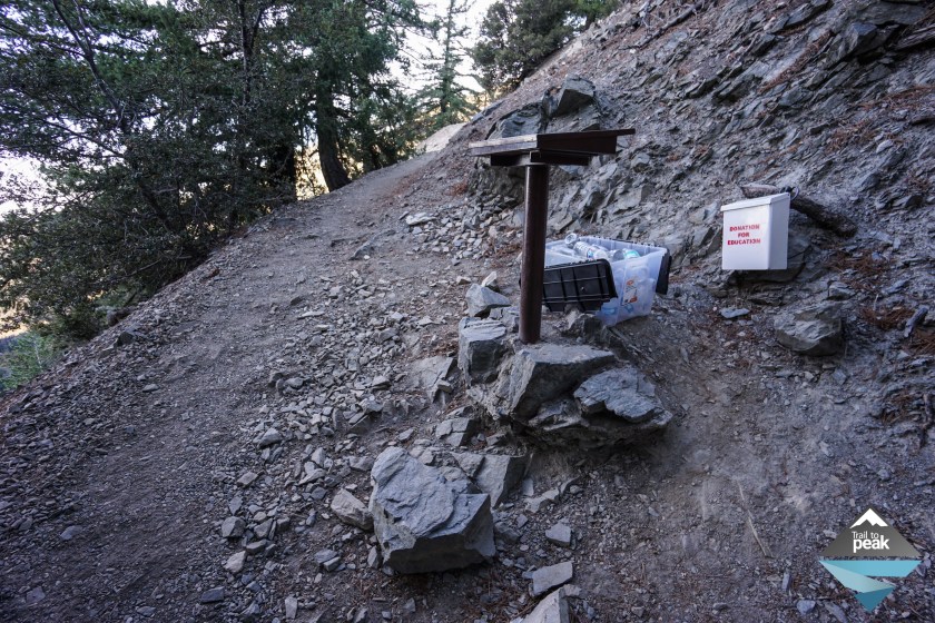
Head up the Ski Hut Trail and you’ll see a trail register post on your right hand side. This is where you want to start keeping a close lookout for the Register Ridge use-trail. On my GPS, the use trail is about 1/10 of a mile past the trail register post. There isn’t really a major junction to signify the Register Ridge Trail, but there is a clear indicator in the form of a trail of rocks. You can see them to the right in the photo below. The junction is subtle, and for good reason. This is not the kind of trail rangers would want beginner hikers venturing off on. If you look up above the trail of large rocks, the use-trail comes into view a little more clearly.

The Register Ridge trail doesn’t waste any time getting you uphill. If your climbing legs aren’t ready at this point, you better get them in gear. The footing in the early stages is really good, with intermittent patches of loose gravel and shifty earth.


One of my favorite things about the Register Ridge trail is the views. To your left you’ll see the Ski Hut Trail, Green Ski Hut, Baldy Bowl, and Mt. Baldy. To your right, you’ll see the Notch Restaurant, Telegraph Peak, and Thunder Mountain. The other special treat is the changing views as you stop to look back. With each turn your perspective of the Inland Empire expands.
Unlike some trails, there really isn’t any trail navigation or direction instructions needed for this section of the hike. Since Register Ridge follows a ridge, you just need to keep heading upward. Even if you loose sight of the use-trail, keep heading up and you’ll find your way back on track shortly.


The second mile of this Register Ridge hike really put my legs and lungs to work, going from 6800ft to 8400ft! As taxed as I knew my legs were, my mind kept my body pushing forward. It was at this moment on the trail that I came across the first group of hikers I had see on Register Ridge. That is another great thing about this trail. Unlike Devil’s Backbone and Ski Hut Trail, Register Ridge gives hikers lots of alone time.


At the 2 mile mark a large mass of boulders sits in the middle of the ridge. Take the use-trail path to the left and continue moving upward. At this point, most of the difficult uphill work has been completed, and only a .5 mile stretch of trail remains before meeting up with the Devil’s Backbone Trail.


At. 2.5 miles, Register Ridge intersects with Devil’s Backbone Trail. Continue on Register Ridge if you want to reach the summit of Mt. Harwood, or take a left if you just want to summit Mt. Baldy. Keep in mind that you don’t have to backtrack if you’d like to summit both, you can descend the northwest ridge of Mt. Harwood to continue on to Mt. Baldy.
The path to the summit of Mt. Harwood is another use trail. Keep heading towards the highest point to reach the summit.


The summit of Mt. Harwood offers nice views of Mt. Baldy and the High Desert. Take some time to enjoy the views before heading northwest towards Mt. Baldy. To continue on to the summit of Mt. Baldy without backtracking, follow the Harwood ridge past the solar panels and weather monitor.


Once you’ve descended the northwest side of Mt. Harwood, there is just one last uphill to hike. This final stretch covers about 6/10 of a mile and goes from 9400ft to 10064ft. After hiking Register Ridge, this stretch of trail will seem like a cake walk for your legs, the only problem is that your lungs will definitely be feeling the lack of oxygen.


Once you’ve reached 3.7 miles of hiking and 4100ft of elevation gain, you’ll be standing on the summit of Mt. Baldy. Mt. Baldy, formally known as Mt. San Antonio is the highest peak in Los Angeles county at 10,064ft. The summit offers incredible views in all directions, and on clear days you can see all the way out to Catalina Island. Take some time to enjoy the beautiful California scenery and rest your weary legs for the descent.


You’ll have a few options for your return. The first option is to head back the way you came. Register Ridge is a very steep trail though, and I’m not so fond of heading downhill when the trail regularly reads at grades of -30% to -40%. On this day, I opted to head back the way I came, but instead of taking the right hand turn to descend Register Ridge, I continued on to Devil’s Backbone towards The Notch Restaurant and fireroad. The third option is to hike down via Ski Hut Trail, which is another great option.
I hope you enjoyed this hiking report of Register Ridge. Leave me a comment below and feel free to ask me any questions you may have.
Looks like a great hiking challenge!
It’s a really nice lung and leg burner!
Baldy is a great and challenging hike and I’ll have to try Register Ridge next time, thanks for the post! ✌
You’ll love it, Rechito! It’s a beautiful trail.
Great post. I’ll remember this one for future reference. Thx.
Thanks, Mike!
I like the format of your post. Great info, easy to find.
Thanks, Caroline! I’m transitioning to writing full hiking guides in lieu of just doing trip reports. It’s a little more work, but hopefully much more useful for those looking to find hikes in this area.
Wow your blog is great! Super informative! Glad I came across it!
Thank you!
I’m going to have to check this out!
It’s a great hike!
Register Ridge is my favorite way to do Baldy. Great on crowded weekends as you’ll usually have it all to yourself.
I agree. Such a nice break from the crowds of Devil’s Backbone and Ski Hut Trail.
Thought I was taking a shortcut hiking down register ridge today. Nightmare. Although shorter, it was so steep, loose and slow going it took longer tha heading Dow devils Backbone Trail and the fire road.
Landed on my A at least 4 times.
That’s a tough mistake to make. Heading down RR is no easy task. At least you were able to make it down in one piece.
What’s the total mileage with Mt Harwood and Mt. Baldy?
3.75 miles