
Today I finished hike number 48/52 for the 52 Hike Challenge in 2015. I made my way out to Angelus Oaks early this morning to tackle San Bernardino Peak. This hike is 16 miles round-trip with about 4500ft of elevation gain. Unfortunately, I had to leave Isla behind on this one. A few months ago, researchers found two dear ticks infected with Lyme Disease in the Angelus Oaks forest. With all of the low lying brush and shrubbery on this trail, there was no way I was taking a chance with my precious little pup.
I arrived to the trailhead at 7am, and noticed fewer cars in the parking lot than usual. The weather has been a bit strange this week, with brutal heat and lot’s of humidity. Very unusual for Southern California. According to the weather forecast, the humidity is on it’s way out. I could definitely see the weather pattern changing as clouds of different types formed across the horizon and swirled in the wind. The cloud cover was very nice, as my last few outings have been under an empty sky with lots of sun exposure.


Even though it was just past 7 am, the humidity in the air had me sweating. It’s very unusual for it to be that humid above 6000ft. I pressed on and entered the San Gorgonio Wilderness. Seeing this sign makes me remember how lucky I am to have the San Gorgonio, San Jacinto, and San Gabriel wilderness areas so close by.


The beautiful thing about this trail to San Bernardino Peak is the way it climbs in sections. The first few miles ascend rapidly before leveling out for a nice stretch along a flat ridge. It’s always nice to have a peak bagging climb that allows for a little trail relaxation. It was especially nice today with the everchanging sky.
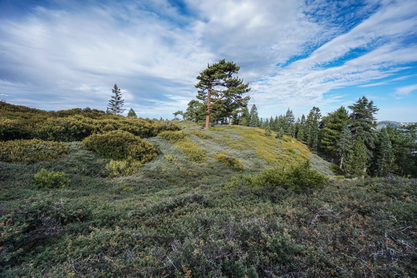


I always know the flat land is about to end when I reach the junction for John’s Meadow. That trail goes downhill, I take Limber Pine to continue on towards San Bernardino Peak. The switchbacks after the junction are pretty easy to handle, and offer a few spots to walk off trail to take in the views of the Inland Empire. There’s one lookout in particular that has a flat slab of granite for a bench. The views today were incredible. I could see San Gorgonio, San Jacinto, and all of the peaks in my backyard range, the San Gabriels.


After taking a few photos at the lookout with the bench, I continued upward towards the Washington Monument and passed 10,000ft of elevation. Only 700 more feet to go.


There is only a short distance left to San Bernardino Peak after leaving the Washington Monument. I’m not sure if it’s the amount of time I’ve spend at altitude, or the lack of sun beating down today, but I was feeling really fresh when I reached the summit. I took off my pack, and spent some time enjoying the views.


The clouds were really starting to darken as I began to make my way down. I felt a drop or two here and there, but nothing seemed charged about the clouds overhead. Luckily, rain never fell, and the walk downhill was just as pleasant as the walk uphill. Another great hike in the books, and it’s almost time to close out the 52 hike challenge for 2015.
Nice job! You are bringing me back for a few weekends ago. What hikes are left in your 52 challenge?
Thanks! I’m thinking Mt. Whitney, Mt. Langley, San Gorgonio, and the Grand Canyon. I’ll have to wait and see how much time I have on the weekend to drive to the destination places. I may end up doing some hikes closer to home.
Looks amazing, as usual. Looking forward to the next 4 hikes! Next year I will do the 52 hike challenge myself if I can find some good gear for the incessant rain, haha.
It’s crazy that I only have 4 left. I haven’t run a tally yet, but I think I’m around 700 miles for the year. I might have to bring back that 1000 mile goal to keep pushing through December! your 52 hike challenge will look much different than mine. All that rain will make for quite the challenge. You’ll have a much greener landscape to look at though!
It’ll be more like having to hike 26 in a month or something…maybe this year we’ll have a more stable winter…and the second half I *should* be moving to a sunnier part of Spain. Would days on the Camino count though? As I’m doing Santander-Santiago next June…
Wow, the weather must be really wet where you are! Hopefully your future holds warmer and dryer weather in a new location! The Camino will definitely count. I counted my days on the JMT 🙂
I think it’s about 20 days from Santander, but that’s rainland too. The north of Spain has the same climate as the Pacific Northwest. It rains more in Bilbao than Dublin and Seattle (but Seattle technically has more rainy days.) Today is Day 4 of rain and I’m itching to be outside already 🙂
That’s what I’ve heard. I was so lucky on my Camino to only have one day of rain in Galicia. I even got a sunny and clear day in Finisterre. It’s crazy to hear the Bilbao rains more than Dublin and Seattle! I can see Seattle having more rainy days though, as it’s always more of a light drizzle and not a crazy downpour. Four days of rain in a row is a lot! We’re going though a drought here in So Cal, so I’m still praying for more rain!
Last winter it went from Jan 7th until March 7th with only three days without rain, and one of them was snow. It’s supposed to be drizzle here, but it’s actual rain most of the time. Galicia rains even more than Bilbao though. The rain in Spain never even reaches the plan 😉 I’ll gladly 75% of the rain as that should help out with the drought and we’ll still have plenty not to be in a drought.
Hey Drew, I plan to to San Bernadino soon for the first time and most likely solo. Is the trail hard to follow at any point?
Gary, the trail is pretty straightforward. Finding the trailhead is a little bit of a challenge though. When you enter Angelus Oaks, you’ll see a fire station. Turn right on Manzanita and take a quick left right in front of the fire station. After that, you’ll see a sign for the trail, where you’ll head right onto a dirt road. Once you’re on the trail there are only two junctions. The first is the trail sign I have pictured above. Take the Limber Pine route. The final junction is just below the summit. You’ll veer right once you near the 8 mile mark. There is no sign, so just be cautious not to miss it.
These are amazing photographs. I have recently gotten into hiking over the past year or so. Just beautiful.
alifeelectric.com
Thanks, Molly!
really got to me.